Whoever defines India, whoever speaks to and for its people and whoever imagines its destiny with the hope of determining its future…can stake their claim to ownership of India by the very act of writing about it. Teresa Hubel: Whose India? (1996).
1 Space, place and identity
In humanistic geography, space and place are important concepts. Space is something abstract, without any substantial meaning. It is a location which has no social connections for a human being. It has observable boundaries but no meaning has been ascribed to it. Space constitutes a simple geographic reference point. It is by having cultural significance that space becomes place; a human resource on its own. It becomes valued visually in memory and is thereby protected as landscapes. (Figs 1, 2 & 3)
Place refers to how people are attracted to a certain space and endow it with a sense of belonging rather than merely passing through. In this connection, a place can be seen as space that has been given a cultural meaning. In other words, ‘Place’ is a location created by human experiences. It exists as space that is filled with meanings that come from what people appreciate and value about it. Their ‘place’ is personal and multi-dimensional. It is temporal as well as spatial, because it thickens with the addition of physical elements, personal memories, local stories, history and archaeology. It is not just a question of how things look, but of how things feel to those who know a place well.
Spaces are turned into places through human settlement. Place becomes central to the settlers identity. In this context, identity is an even bigger issue than race, filling our imagination and requiring careful attention. Indeed, identity is a major preoccupation of our times. Many people are on a quest to determine who they are, how they belong and where they fit in. Refugees are searching for roots in distant and foreign lands. Indeed, within the great scheme of things humanity has always been on the move, fitting in where it can find a more lasting identity, something above and beyond the mere physical and material to give meaning to their lives. People begin this search from being somewhere in nowhere land, wanting to belong. Identity won’t happen on its own, you have to give birth to it, work at it and create it through an act of will.
This attachment is defined as landscape, i.e. a “place” with its meanings and contributions to societal identity. Places are mapped and landscapes are pictured. A map is a symbolic representation of selected characteristics of a place, usually drawn on a flat surface. A landscape is the visible features of an area of land, its landforms, and how they integrate with natural or man-made features. Places are mapped and landscapes are pictured. A landscape is the visible features of an area of land, its landforms, and how they integrate with natural or man-made features.
First and foremost, landscapes are perceived as a physical space, covering topics such as environmental preference and the evolution of the psychological processes through which preferences arise. Second, landscape is perceived as place within concepts such as “sense of place” and “place identity”. Place identity is a particular element contributing to sense of place. Third, landscapes have a role in psychological wellbeing.
Numerous studies have shown that participation in leisure activities out of doors not only prevents disease and improves physical health but also benefits mental health by reducing anxiety. Psychological restoration bridges the approaches that treat landscape as space and those which treat it as place. Actually, the European Landscape Convention (2000) conceptualises ‘Landscape’ as being made up of both space and place. Advocates of place-based education can accommodate public participation and negotiation to identify local knowledge and sense-making practices. This process is particularly important in local planning to support sustainable development.
How do practices on the ground transform; what motivates people to transform (needs); what should be changed or transformed (challenges); how to transform these via innovations and through which practices transformation can be achieved.
If communities are to fully embrace the ethic of landscape sustainability, they must be the primary agents for change in that landscape, not simply the beneficiaries of changes originated or mandated by others. This agency is expressed and actions on the ground accomplished through local organizations that can channel and interpret local needs and demands into effective collective action. However, community organizations such as cooperatives, advocacy groups, church groups, and self-help groups, will pursue sustainable management of their place and its resources only if the benefits of doing so enhance the economic and social wellbeing of the people who belong to these groups. Community groups must own the process of place planning and management if it is to be sustainable. This ownership is built when these groups decide for themselves the social, economic, and ecological objectives of landscape management, the modes of implementation, the indicators of success, and the lessons learned. By reflecting on the decisions they have made in implementing their own initiatives, local groups build their capacities to continuously adapt to ecological, economic, and social challenges and opportunities.
2 Parish SCAN
Local government planning exists to solve community problems. People need to bother with environmental appraisal because any inadequacies of community life will only be overcome by the community itself. There is no doubt that any community has the skills to do this, by recognising that things can be changed for the better, and that each individual contribution brings satisfaction to the individual, as well as benefit to the community.
It was only in 1969 that central government recommended setting up machinery for the public to participate in planning. From this time it became urgent to find methods to involve people actively, from grass roots, in the problems, issues and challenges of managing local change. In the 1980s attempts were made to formalise ‘village appraisals’. The aim was to encourage communities to map their neighbourhood; its character, history and social needs. However, the original flexibility of approaches and methods was quickly lost when the system was hijacked by organisations requiring specific information from communities to direct their top down funding. ‘Form-filling’ turns most people off, particularly when the subject matter does not act as a conduit for their particular local passion.
Parish SCAN was a reaction to official form-driven environmental appraisal. It was actually invented, in 1995, by Welsh teachers responding to Rescue Mission Planet Earth, a summary made by young people of the Rio action plan known as Agenda 21. SCAN is a voluntary process, originating in the outcomes of the 1992 Rio Environment Summit aimed at creating local policies and programs that work towards achieving sustainable development. SCAN, as originally envisaged, encompasses awareness raising, capacity building, community participation and the formation of partnerships. The objective was to bring children into the appraisal system by creating social links with communities served by their school to boost information gathering and databasing. Its advantage to the school is that the neighbourhood where a child actually lives becomes its outdoor classroom. For the community, the school becomes an information technology centre for long-term recording, and citizen networking. SCAN is therefore a flexible holistic system. It can begin, either in a school (School SCAN), or in one of its communities, (Parish SCAN), with the aim of eventually uniting both bodies to make, and manage, environmental improvements.
Parish SCAN was the option chosen by the village of Parham in Suffolk as its contribution to the millennium celebration.The Parham Parish SCAN is a detailed record of the village as it was at the beginning of the 21st century, with a browse through its history and a tentative look into its future. It was prepared by village people, for village people and is a comprehensive record of the life in their village. The data was organised in three chapters; a glance at the past; aspects of the present and an appraisal of the future. The final publication was the result of many hours of dedicated research by parishioners who hoped that it may be a testament to life in Parham as it was seen by its 113 households in 2000, as well as a fitting tribute with which to mark the millennium. It is important to stress that SCAN was a grassroots initiative driven by the Parish Council under their tireless Clerk. In this context, Blything and Nine Parishes was brought to fruition by a resident historian with ancestral roots in Suffolk going back to the 16th century and beyond. In other words, local residents have to ‘step up to the plate’ to make things happen.
Like all villages, most of Parham’s parishioners commute to earn a living. With no shop or school Parham has to cope with the common problems of rural placelessness. It is significant that SCAN was adopted after the village had carried out an appraisal and was awarded Suffolk’s Village of the Year. The aim was to sustain the momentum and tap the wider community. Although not a tourist centre, Parham has plenty for its inhabitants to become passionate about. Set in a classic glacial landscape, it has a rich social heritage; a centre of Saxon local government; a power base for Tudor politics; a front-line airfield during the Second World War. A store of wildlife is embedded in its woodlands, ponds and field boundaries. However, the SCAN published as a 170 page professionally bound book, shows what any community can do to develop social roots, and the organisation required to bring such a project to fruition. The vision of the parishioners was that the Parham story would continue to be developed by its 300 parishioners as their contribution to a local Agenda 21 Citizen’s Environmental Network, incorporating year-on-year checks to measure change, and ensure things change for the better.
3 Cultivating the ‘background hum’
Because of increasing geographical mobility, economic change and the rise of an individualist culture in the UK there has been a loosening of close ties in communities. Indeed, today’s dynamic, rootless communities need to evolve, to reconnect, so that people cultivate the background hum of sociability that has long been associated with neighbourliness. The giving and receiving of help within communities is an aspect of social life that is taken for granted, yet it is little researched or understood. It was the subject of research by the Joseph Rowntree Foundation, entitled Landscapes of Helping: Kindliness in neighbourhoods and communities (2015).
Social connectivity increases the likelihood that people will be known to one another, have their needs recognised and have people to draw on for support. Therefore, in identifying mechanisms which foster kindliness we also describe those which simultaneously build neighbourliness and sociality as the foundations of place. It’s premise was that kindliness cannot be considered apart from wider processes of individualisation which are often perceived as threatening social bonds. The belief is that, given certain conditions, cultures of kindliness can still be developed; based on emotional attachments, shared values and social forms that actively sustain relationships of trust and mutuality.
This Rowntree study explored ‘kindliness’, or informal helping, in Hebden, a semi-rural location in West Yorkshire, in order to understand how it can be fostered in communities. In particular it identified the following conditions that may help kindliness to flourish in communities.
Making kindliness palatable – it was important that kindliness was facilitated in ways which were sensitive to language and presentation. If people retained a sense of personal independence and dignity they were more likely to ask for and accept help. Non-help-focused conversations and activities could help people express their needs indirectly.
Nurturing bonders and bridgers – Hebden had many people who worked to strengthen the bonds between individual members within communities or ‘bonders’, as well as people who worked across different sections of the community or ‘bridgers’. These people were important in facilitating one-to-one kindliness and also creating connections between different sections of the community.
Building common cause – it was important that people had opportunities to come together to articulate experiences. In Hebden, communities expressed these shared values when uniting to defend common values and build ‘common cause’ because this offered a means to break down barriers and mis-perceptions, enabling people to appreciate that they have similar values and experience the landscape or by coming together through shared interests. Hubs of helping to create a sense of community can be more easily developed when there is an identified focal point for people to share information and make contact with others. The erosion of such facilities as shops or Post Offices has been detrimental in many neighbourhoods and this research highlighted how important it is to develop ways of connecting communities. In Hebden this had taken the form of ‘virtual hubs’ such as Google groups or Facebook pages and the creation of a wealth of formal, group based associations. In addition, the idea of community-run shops, pubs and other local facilities offer promising new possibilities.
Third Spaces – a conscious attempt to create public spaces where people could come into daily informal contact was key in promoting sociability and trust. Public space has long been an essential feature of urban housing design, yet it is not always ‘owned’ by people locally. It was important that the development of space tapped into the emotional connections people had with their neighbourhood. Creating kinder economies – social enterprises whose business aims were about more than the ‘bottomline’ worked to support local networks and facilitate helping. In Hebden this relied on people having the resources and time to develop alternative business models, as well as resist threats such as the encroachment of big corporations.
Creating a shared myth (a story) – it seems important that people feel a strong sense of attachment to the place where they live because if they value a place they are prepared to invest in it and in the people who live there. In Hebden this was built around its positive unifying features and expressed through community-wide events, communicated in local media and through newsletters and joint ventures around common interests.
Of these mechanisms creating a shared myth (a story) is the most fundamental condition because without it individuals cannot fully define their presence in space as having a continuity with the past and an identity with those who have come before.
4 Place ambassadors
The designation ‘place ambassador’ was created in the SUSPLACE programme (2015-19), a European Marie Curie funding scheme aimed at training early stage researchers in innovative, interdisciplinary approaches to study sustainable place-shaping practices. With the motto, ‘Shaping better places to live and visit’ SUSPLACE involved two community engagement projects in two distinct locations: the Portuguese village of Carvalhal de Vermilhas and the Brecon Beacons, a National Park in Wales. In both places documentaries were produced together with residents, which helped them become place ambassadors. They became confident in promoting their attachment to the cultural heritage expressed as landscapes imbued with valued elements, such as footpaths and ways of life, expressing the slower pace of a preindustrial economy. Their stories were valued by urban dwellers seeking respite from the stresses of consumerism.
Carvalhal de Vermilhas has around 200 inhabitants. It faces depopulation, an ageing population and lack of employment, but has the potential to develop sustainable practices in tourism. Brecon Beacons is in a somewhat better economic situation, but suffers from similar issues. Being a national park, tourism is already one of its main activities. In both places, the researcher worked together with residents to test a new conceptual framework and to develop a co-produced documentary. The projects are an example of collaborative and inclusive strategies of place branding. By participating in the projects, the residents had a say in how they would like to shape their place with regard to tourism policies and development. The resulting documentaries show the intangible heritage of the places and communities. They are also used as a tool to allow residents to reclaim their right and power as citizens to shape their place according to their needs and place values. Ownership and responsibility as well as shared power over the visual narratives mobilise participants to take action for their place. Co-producing the documentary also motivated residents to be more effective and become collective ambassadors of their place. Moreover, the two documentaries can now be used to promote the places more effectively to visitors, and potentially also to new residents and young people.
5 Know your place
‘Know Your Place-West of England’ was a top down local authority initiative to support individuals who wished to explore their neighbourhood online through historic maps, collections and linked information. It was established in 2015 and ran until 2017 as a digital heritage resource to help people have online access to a range of local historic data. But more importantly it provided an online heritage hub where people could add information about their local area, building a rich and diverse community map of local heritage for everyone. It was free to use and anyone could add to the shared map.
Know Your Place achieved the following Approved Purposes:
- To scan, digitise and geo-reference historical maps from Gloucestershire, South Gloucestershire, Wiltshire, Somerset, North Somerset, Bath and North East Somerset and Devon.
- To recruit and train volunteers. The project recruited c.100 individuals and 70 went on to volunteer for the project, giving 4946 hours’ work to the project.
- To deliver basic conservation of fragile maps. Maps were stabilised for safe digitisation and their access online is reducing physical handling and wear and tear of the original documents.
- To create a mobile app. Know Your Place has been designed to be compatible for use by smartphones, tablets and other devices while on the move.
- To create an exhibition to be toured to six venues. The exhibition toured 12 venues, and remains available online.
- To deliver a range of heritage learning activities including talks and presentations, a blog, heritage walks, school resource packs and oral histories. The events programme ran 98 events reaching 2689 people and has now ended.
- To upload condition surveys of heritage assets to the website. By July 2017, 1197 public contributions had been added to the Community Layer, at an average rate of 180 per month.
6 “Blything and Nine Parishes”
‘Blything’and Nine Parishes’ was an EC funded project launched in the 1990s. The aim was to evaluate IT methodologies for individuals and communities to collect data about places and create knowledge about the long-term changes in cultural spaces. SCAN ( Schools in Communities Agenda 21 Network) was the practical element of ‘Blything and Nine Parishes’. It was associated with the creation of a new school subject about world development called natural economy, produced by the University of Cambridge Local Examination Syndicate. This initiative was aimed at embedding the United Nations Charter in the education system, particularly with respect to practice, tolerance and living together in peace with one another as good neighbours.
Blything and Nine Parishes models two of the ancient groupings of Suffolk villages into divisions called hundreds. They were chosen to model neighbourliness because they have survived as social units of local government for over a millennium and today they are examples of extreme rurality. This blog revisits Blything and Nine Parishes with a new collection of websites presenting notes on landscape elements in the hundreds, culled from maps art and writings, exploring how people can shape more sustainable places together. In this blog, Blything Nine Parishes is compared and contrasted with four other similar community initiatives aimed at strengthening the capacities and autonomy of people in places to take a grip on the uncertain future.
The Blything/Nine Parishes project was designed to test an innovative methodological procedure at the dawn of IT and the Internet, which would involve residents with personal computers networking to reclaim their sense of place in modern processes of rurality. The objective was to gain an understanding of the long-term development and transformation of rural life, drawing on insights from topography, archaeology, geography and historical ecology. This ‘background hum’ is characterised by people’s awareness of each other, by a respect for each other’s privacy and by a readiness to take action if help is needed. The central question is can kindliness be defined as ‘neighbourliness-enacted’? Also, can kindliness describe the process of reconnection within communities as the ‘reinvention of sociality’ ?
In contrast to Know Your Place, Blything and Nine Parishes was a bottom up initiative. Its philosophy was that a community’s past is stamped into the land by the people who first decided to settle there and negotiated boundaries to ensure its sociopolitical and and resource sustainability. Such was the origin of two places in the UK county of Suffolk named ‘Blything’ and ‘Wangford’. These places are examples of ancient administrative divisions, called ‘Hundreds’. Geographically, each is part of a larger division. The term “hundred” is first recorded in the Saxon laws of King Edmund I (939–46). Here it is presented as a measure of land defining the area served by a Hundred Court. The origin of the division of lands into hundreds is obscure. It may once have referred to an area of 100 hides. In the early Anglo-Saxon period a hide was the amount of land farmed by and required to support a peasant family. Alternatively the hundred may have been an area originally settled by one “hundred” men at arms, or the area liable to provide one “hundred” men under arms.
In the Domesday Book Blything Hundred comprised 56 named places with around 2000 households. The Hundred was aligned with the watershed of the River Blyth which reached the sea at Dunwich. In Anglo Saxon times Dunwich was by far the largest of the coastal havens situated between the North and South Hundred Rivers. These two rivers marked the northern and southern coastal boundaries of Blything Hundred . The name Blything suggests that it was an ancient place occupied by a group of self-governing farmers known as ‘people of the Blyth’. Land divisions are often older than we think and from this point of view there has been speculation that Blything could be a British tribal area predating the Roman occupation. Without doubt this makes Blything a good place to develop a shared myth amongst its inhabitants.
Regarding Wangford Hundred, this hundred is written in Domesday Book as Wanneforda and Waineforda. Some historians believe this derives from an alternative name for the River Waveney, Wangford’s northern boundary, and thus it meant “ford for wagons across the Waveney”. However, British History On Line believes the hundred takes its name from the village of Wangford, which is actually within Blything. The community of Wangford within Blything is named after the ford which was a major road crossing of the River Wang, a tributary of the River Blyth. There were 24 places in the hundred of Wangford in Domesday Book. Nine of its present parishes were selected for comparison with twenty three selected from Blything, which are on its boundary.
This blog revisits Blything Nine Parishes with new websites presenting notes on landscape elements, from maps art and writings involved exploring how people can shape more sustainable places together. https://sites.google.com/view/suffolkscan/home
Taking a long view of Suffolk places there was certainly human occupation in the area we now know as East Anglia before the great Anglian Glaciation around 450,000 years ago, but most traces of it have been obliterated by scouring ice. On this human time scale people first arrived in Britain at least 780 000 years ago and have recolonised East Anglia after several major glaciations to leave an archeological pattern of occupation closely related to the shifting climate. Pakefield, at the mouth of the North Hundred River, is the site of one of the earliest known areas of human habitation in the United Kingdom. In 2005 flint tools, and teeth from the water vole Mimomys savini, a key dating species, were found in the eroding cliffs. These are the markers for the earliest hominins in England about 700,000 years ago, potentially a cross between Homo antecessor and Homo heidelbergensis. Of all the glacial periods Britain went through in the last million years, the Anglian glaciation was the most extreme. Human survival in Britain became impossible. The absence of humans lasted for many millennia. After the glaciers finally retreated, somewhere between 10,000 and 8,000 BC, the waters of the Atlantic spilled over into the North Sea as the ice-sheet melted. Gushing melt waters carved out the valleys of Suffolk’s rivers, which today cut through the clay plateau. These valleys are very large in relation to the actual size of the streams that flow in them. With this warmer phase, the tundra, an expanse of frozen subsoil, gave way to birch and the willow scrub, which was eventually followed by forest with pines and oaks. In the open grasslands the bison, mammoth and hippopotamus lived, and as the reindeer herds gradually moved north, the woods were once more inhabited by red deer, pigs and auroch cattle.
Around 7,000 years ago the coastline of Suffolk lay some 7 km to the east of its present location, and the land was forested with oak, elm, lime and alder. This space became the hunting ground of nomadic Mesolithic hunter gatherers whose flint tools have been found on the southern bank of the River Blyth at Halesworth. At the small Halesworth encampment, scrapers, burins (a kind of flint chisel) and borers were found. Also excavated were several potboilers, pieces of flint which were heated in a fire, then dropped into a water-filled skin bag in order to cook meat.
The history of Britain’s population is all about arriving, staying and settling, or leaving, moving and settling elsewhere. Farmers from continental Europe began to settle in different parts of Britain after the last Ice Age, around 12,000 years ago. Ever since, these islands have been continuously occupied as new arrivals mixed with existing residents. Neolithic farmers settled along the fringes of the glacial clay plateau, where the slopes of the river valleys were easier to drain and cultivate than the central claylands. The latter had developed a thick tree cover, but spaces were becoming places as people began to carve out farmlands from the primary woodlands. For example, at Henham on the Blyth estuary, groups of Beaker flat graves have been excavated together with extensive Iron Age remains of clay-lined pits and part of a large circular building. Elsewhere, in Suffolk extensive prehistoric coaxial field systems have survived.
By the 1st century human settlement was expanding into the central wooded areas, and at the end of the Roman occupation a network of dispersed Saxon settlements spread across the area. At the time of the Norman Conquest, the present villages and many isolated farmsteads and hamlets had been established and Suffolk was one of the most densely populated in England.
Names of some villages we have today come from the Anglo-Saxon settlers. Some were named after the chieftain (leader) and end with ‘ham’ or ‘ing’. Today’s parish boundaries originated in the territorial divisions of these families. Beating the bounds is an ancient custom still observed in some English and Welsh parishes. Under the name of the Gangdays, the custom of going a-ganging was kept before the Notman Conquest. A group of old and young members of the community would walk the boundaries of the parish, usually led by the parish priest and church officials, to share the knowledge of their community’s space, and to pray for protection and blessings for the lands.
Culture and space are now mapped into parish boundaries that can redefine:
- the notion of place;
- the production of creative goods and services;
- the importance of history;
- the intrinsic value of what is local and unique.
- the ethic of landscape sustainability
Therefore a parish can be interpreted as a socially constructed narrative, locking people into their environment. As a narrative it can be understood in two ways: as a means to make sense of the world (a way of knowing) and as a practice (a way of doing), Language is used to build ‘knowing’ and ‘doing’ into local knowledge via storytelling. Places are reproduced and communicated by telling stories. Indeed this process of creating environmental knowledge starts with an exploration of people’s sense of place, which governs their attachment to their environment and their desire to protect it.
Fig 1 Hundreds of Suffolk (a SPACE in SuffolkSpaces)
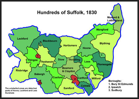
Fig 2 Map of Benacre Parish, Suffolk (a PLACE in Blything Hundred); boundary in red
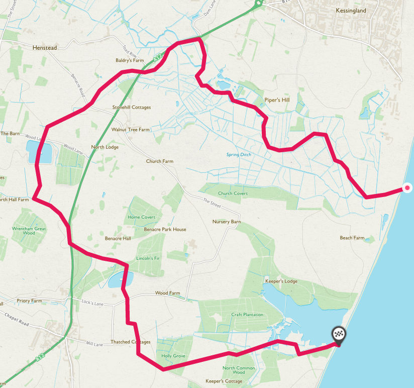
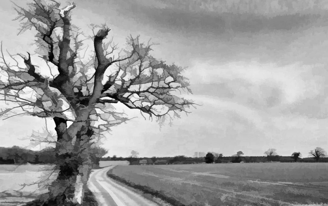
Fig 3 Lock’s Lane, Benacre (A LANDSCAPE in Benacre)
7 Postscript
The value of cultural heritage is generally recognized as being an important factor in creating sustainable and resilient human settlements In particular, the local evaluation of heritage underlines the importance of protecting and enhancing the identity values of places. The objective is to guarantee an inclusive and fair human-centered community development. Heritage interacts actively with people, bringing them together reinforcing and blending the sense of identity and belonging. Taking all of this into account, the future of sustainable communities lies with IT as a collection of tools for gathering and disseminating information and knowledge about the past, present and future of ‘place’. IT has not killed physical space. Instead, the digital, the physical and the cultural can be recombined in new updated versions of place. Here the internet has entered physical space becoming the Internet of Things (IoT) and it is changing the way we interface with the space around us. Communities are at the center of place-innovation that is unfolding across all geographic, industrial and technological borders. It is not so much devices that are being linked together but the “connected person.” At the center is a person who is making use of the IT applications and services that are enabled by the devices, i.e. the things, and their unprecedented integration. The things express good human behaviours such as thinking of others, considering the impact of one’s actions and being kind.
People in every community will always have to face challenges and will need to find new ways to stay connected and check in on one another to maintain physical and mental wellbeing and share accurate information and advice e.g. for conservation and medical wellbeing. This is the lesson of COVID 19. IoT enables keeping up to date, sharing information and being a positive part of the local community conversations. Different elements and groups will be at increased risk. Social isolation and loneliness are key concerns for all ages. With respect to bringing people together to advocate for community action, neighbourly support can make a huge difference in a world fraught with global challenges. The current threats of global warming and disease pandemics are set to impact all of us in one form or another. With respect to their role as active citizens stronger local connections of people with their community places are vital to see future environmental crises out. Personal IT tools are going to be essential in order to fully participate in one’s community . Already, many people maintain personal web pages to express their opinions on issues ranging from news and politics to movies, or to serve as a showcase for their creative endeavors related to place-making through writing, poetry or music. A personal web page gives the owner generally more control on his or her presence in search results and how they wish to be viewed online. It also allows more freedom in types and quantity of content than a social network profile can offer. They also provide a link from the local world to the individual, and from the individual to the wider word, putting what really matters into a clearer light.
Having a website allows a person to have full control over his or her ‘brand’. They have complete ownership over it. How it looks and what it says are entirely up to the writer, making it the ultimate platform to reflect exactly who they are, why they do what they do, what makes them different and the value they provide. Further to this, having a website gives security and certainty when it comes to the owner as an individual. There are no terms and conditions they need to follow, nor do they have to worry about it shutting down. Many sites, such as Google, are easy to make and free. Having a personal domain also means that the owner can produce content that is exclusive to his or her brand. For example, content in the form of blogs can only be found on that particular website, giving an opportunity to rank in search engines with specific keywords that relate to the impact of the owner on their neighbours and making a difference in the wider world.
In summary, having your own website means building a presence in a village appraisal on your own terms, the way you want it to be. How much more could be incorporated in the Parham Parish SCAN if every family in the village could network its own website?
8 Internet references
The dimensions of place meanings
Its not easy to make a landscape