1 Definition
The North American Ndee are the Western Apache people of the mountainous semi-arid Transition Zone of west-central Arizona. They are notable in linking important allegorical stories to the places where they are said to have occurred, and regularly recount these stories for teaching and counselling. For example, descriptive place names such as ‘Coarse-Textured Rocks Lie Above in a Compact Cluster’ and ‘Line of White Rocks Extends Up and Out’, have long since become shorthand for the lessons they exemplify, and are central to Ndee cultural literacy. The late Dudley Patterson, an Ndee Elder, explains his people’s approach to place-based education as follows. “Wisdom sits in places. It’s like water that never dries up. You need to drink water to stay alive, don’t you? Well, you also need to drink from places. You must remember everything about them. You must remember what happened at them long ago. You must think about it and keep thinking about it” (Basso, 1996, p. 127).
Place-based education seeks to overcome the divide between narrow academic subjects and reality that is blocked out by classroom walls. It achieves this through grounding learning in lived experiences of how local culture tackles real-world problems in the environment and influences decision-making by communities. Education based on place has its roots in John Dewey’s idea of progressive education. According to Dewey, the traditional subject-based, bench-marked linear learning pathways of books undermine the integration of students’ experience outside the classroom and makes it difficult to apply what they learn to their daily life. We have to turn to computers to produce Dewey’s flexible educational frameworks of conceptual mind-maps and place-based pedagogies to bridge this gap (Table 1).
Table 1 Information arrays for learning
The world of books
· Separate subject-based benchmarked pathways;
The world of computers
· Integrated conceptual mind maps
· Comparative place-based pedagogies
An ideal progresssive pedagogy contextualises knowledge in students’ lives. History is taught through researching the stories of places and people, perhaps interviewing elders in the community. Learning about language and arts involves documenting people and events in their places. Concepts in social studies emerge from discovering how local governments operate and how government decisions impact on local communities and families. Science projects monitor local environmental conditions; etc.
In a place-based model, the goal is to collect and compare information geographically. The aim is to create opportunities for learners to think independently (inquiry), collect, analyse, synthesise, and critique information (data), address community opportunities and concerns (values), and create knowledge and innovative ideas (actions). Another major goal that Place-Based Education addresses is communication skills by reporting research findings through publications (written and electronic) and making presentations to peers and the community. If environmental and social data students collect in their communities is standardised and organised in a suitable array, it can be uploaded across the nation into a cultural network on the web. This global networking can be coordinated through school libraries and their information services. The next step is to do research on social and environmental concerns within a large geographic area and make community comparisons.
There is also an important practical outcome from place-based studies. Meanings of places (i.e., sense of place) define and infuse content and pedagogy when students regularly work in the local outdoor environment or in the community. The emphasis on hands-on, real-world learning experiences increases academic achievement by helping students develop stronger ties to their homeland. It enhances students’ appreciation for the natural world, and creates a heightened commitment to serve as active, contributing citizens. Community resilience and environmental quality are improved through the active engagement of local citizens, community organisations, and environmental resources in the life of the school. Teaching that deliberately enriches a local sense of place can potentially stimulate the interest of all students in the cultual attributes of where they live, and the social ways of interpreting them. Where the physiography or cultural geography known by aboriginal inhabitants has been obliterated by urbanization or other changes, visualization technologies can be used to recreate them.
Place-based (also called place-centred or place-conscious) teaching has long been practiced in the United States at elementary and secondary school levels in diverse regions. But an important question is ‘Can teaching based on sense of place suit natives and newcomers equally well?’ It is known that tourists and other visitors can develop strong attachments to places far from their homes. In this connection, Williams and Stewart (1998) remarked that “it is not the possessors of meanings that are local, but the meanings themselves.”
Therefore, whoever defines a place through a process of self-education about its meanings, whoever speaks to and for its people, and whoever imagines its destiny with the practical hope of determining its future can be said to be part of that place. This raises the important question of how local is ‘local’? The answer is that the size of ‘place’ as a learning resource should be defined so it can expand the students’ world as their mental horizon expands. A child’s interest in the world naturally increases in accordance with their cognitive and emotional development. At first there is a natural interest in what is close at hand, 5th grade students have the ability to think at the state or bioregional level, high school students expand their interests to national and global levels. At each level students are grounding their study of large-scale issues, which are geographically based on a solid and personal understanding of how things work in their immediate locality. This means that place must be small enough to handle neighbourhood issues and large enough to set their nationhood in a global context.
2 Wales: a geographical model for a place-based pedagogy
The first border between Wales and England was largely zonal and loosely aligned with the eastern watersheds of the rivers Dee, Wye and Severn. The eastern earthwork known as Offa’s Dyke was built as an early distinct political line running north to south but was subsequently overrun. Ironically, it was The Act of Union with England in 1536, which resulted in a linear political border stretching from the mouth of the Dee to the mouth of the Wye.
Although Wales closely shares its political and social history with the rest of Great Britain, and the vast majority of the population speaks English, the country has retained a distinct cultural identity and is officially bilingual.
The beginning of the 20th century saw a revival in Welsh national feeling. With 20,000 Welsh-born people living on either side of the Mersey in 1901, Liverpool had an array of Welsh chapels and cultural institutions, hosted the Welsh National Eisteddfod in 1884, 1900 and 1929, and gave rise to several leading figures in Welsh life in the 20th century. By the inter-war years, heavy industry in south Wales was increasingly linked to Bristol’s Avonside and the English Midlands, and that in north Wales to Merseyside. The Liverpool Daily Post became, effectively, the daily newspaper for north Wales. Plaid Cymru, ‘The Party of Wales’, was formed in 1925, seeking greater autonomy or independence from the rest of the UK. The decline of Liverpool after the Second World War, and changing patterns of Welsh migration, caused the Welsh presence to diminish; in the 1960s the flooding of the Tryweryn Valley to provide the city with water soured Anglo Welsh relations with many people in Wales.
‘England and Wales’ became common for describing the area to which English law applied, and in 1955 Cardiff was proclaimed the capital city of Wales. Cymdeithas yr Iaith Gymraeg (The Welsh Language Society) was formed in 1962, in response to a perceived decline in the language. Now, the more urbanised south, containing cities such as Cardiff, Newport and Swansea, which was historically home to the coal and steel industries, contrasts with the mostly rural north, where agriculture and slate quarrying were the main industries. Although the M4 corridor now brings wealth into south Wales, particularly Cardiff, there is no pronounced economic divide between north and south as in England; there is, for example, a high level of economic and social poverty and joblessness in the post-industrial south Wales Valleys a few miles from Cardiff.
Referenda held in Wales and Scotland in 1997 backed moves to establish a form of self-government in both countries. In Wales, the consequent process of devolution began with the Government of Wales Act 1998, which created the National Assembly for Wales. Powers of the Secretary of State for Wales, a kind of English Viceroy, were transferred to the devolved government on 1 July 1999. At the same time the Assembly was granted responsibility to decide how the Westminster government’s budget for devolved areas is spent and administered for the benefit of the Welsh people. The 1998 Act was amended by the Government of Wales Act 2006, which enhanced the Assembly’s powers, giving it legislative powers akin to the Scottish Parliament and Northern Ireland Assembly. The current debate is about when and how local tax-raising powers will be organised in Wales.
Despite this broad unity of Wales as a small but distinctive nation, a number of Welsh historians have queried the notion of a single, cohesive Welsh identity. The country is largely characterised by an upland topography and this has traditionally limited the integration between north and south Wales, with the two halves virtually functioning as separate economic and social units in the pre-industrial era. Even today, the main road and rail links run east-west and by rail or car it can take five hours or more to reach Bangor from Cardiff.
As early as 1921 Sir Alfred Zimmern argued that there was “not one Wales, but three”: archetypal ‘Welsh Wales’, industrial or ‘American Wales’, and upper-class ‘English Wales’. Each represented different parts of the country and different traditions. In 1985 political analyst Dennis Balsom proposed a similar ‘Three Wales model’. Balsom’s regions were the Welsh-speaking heartland of the north and west, Y Fro Gymraeg; a consciously Welsh – but not Welsh-speaking – ‘Welsh Wales’ in the South Wales Valleys; and a more ambivalent ‘British Wales’ making up the remainder, largely in the east and along the south coast. This division reflects, broadly, the areas where Plaid Cymru, Labour, and the Conservatives and Liberal Democrats respectively tend to enjoy most political support.
Since the time, a hundred years go,when it supplied most of the world’s energy as coal,Wales has been a significant player on the global stage. It has three UNESCO World Heritage Sites and one UNESCO Biodiversity Reserve. There is cutting-edge international research flowing from its many universities. By making sustainable development the principle of its policy and legislation the Welsh government has positioned Wales in a relatively small group of nations taking a serious practical approach to Agenda 21. This reinforces the idea that civic nationhood appears to have been established as a primary factor in Wales’ post-1997 existence.
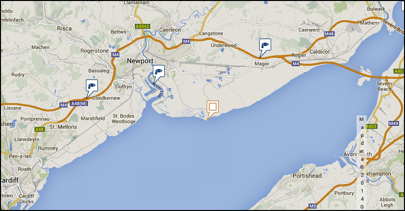
The population of Wales in mid-2008 was estimated at about three million living in an area of about 8,000 sq. ml. It is therefore large enough to express most of the ills of an over-populated planet that is running short of resources. It is small enough to trace government policies to tackle these ills down to neighbourhood levels. As a provisional step to model a place-based educational framework the Green Map System of Wales is being developed as a set of educational arrays (Figs 1 & 2) for comparing resilience planning which combines culture, landscape and ecology.
http://www.greenmap.org/greenhouse/about
Places, which are representative of cultural ecology in action, are cross-referenced to web information files in html, wiki, pdf, conceptual mind maps and interactive power point presentations.
Fig 1 The Green Map System: Wales Cultural Ecology Map 1
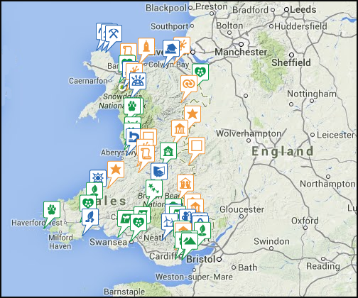
Fig 2 Wales: Cultural Ecology Map 2: Severnside Levels
To summarise, the aim of ‘Cultural Ecology’ maps is to alert the map-reader to problems which humanity is facing at a tempo of change which is entirely novel. These environmental problems and the human response are encoded in past landscapes where they are revealed as prior solutions to, and outcomes of, environmental challenges that are strikingly similar to their modern counterparts. That is to say for millennia humans have had to cope with deforestation, soil erosion, floods, desertication, loss of biodiversity and climatic change. These same factors are often invoked as causal triggers responsible for the formation and decline of archaic societies around the globe.
In many regions of the world, changes in political power, demography, and social organization have been wave-like. Likewise, climate and other environmental phenomena cycle and vary over time. Correlations between climatic and cultural changes are invoked in some regions as causal agents for change. It is impossible to assess and evaluate these relationships without a long temporal perspective that takes into account the organizational, economic, and environmental parameters prior to, during, and after climatic and cultural events in a given region.
All in all, the positive accomplishments of human ingenuity in the past 150 years overshadow all the previous achievements of mankind since the beginning of the Neolithic revolution 15,000 years ago. It is necessary to concentrate on so small a fragment of time because the last two hundred years has been a phase of ecological mutation worthy of comparison with the transition from food gathering and hunting to tillage and pasture. It is also necessary to attach this time interval to a small geographical area that illustrates this increased tempo of change and the resilience of its people for adaptive management of social change. A cultural ecology map can therefore provide an educational resource to explore the nature of interactions between these social and ecological systems.
Also, new insights into the social-ecological resilience of cultures come from mapping the concepts of ‘driving forces’, ‘thresholds’, ‘adaptive cycles’ and ‘adaptive management, on the ground and in the mind. This is a process of social learning. The practical goal of cultural ecology mapping is to promote resiliency plans for achieving long-term environmental occupacy of a locale by learning about how the complexity of the landscape is the result of the resilience of past generations who changed their behaviour to maintain flows of ecosystem services.
The underlying purpose is to take up the challenge, first articulated by Tim O’Riordan, and examine the drift towards a more inclusionary and deliberative politics. The task is to assess how far attempts to incorporate such approaches have worked in coservation management, and to examine its prospects in an emerging world where enduring management of ecosystem services may well have to be provisional and participatory. O’Riordan takes the view that in today’s complex and specialised politics, full-blooded participatory democracy cannot replace some form of accountable representative democracy. This will enevitably lead to reslience plans being compromises to achieve a new balance between ecosystem services and economic well-being. Relationships between culture, landscape and ecosystem services will inevitably change to reflect this balance.
Further information on these themes and access to the cultural ecology maps of Wales may be found at the following three sites.
http://www.changingtimes.wikispaces.com
http://www.opengreenmap.org/greenmap/wales-cultural-ecology-map-1
http://www.opengreenmap.org/greenmap/wales-cultural-ecology-map-2
3 References
Basso, K.H., 1996, Wisdom Sits in Places, Albuquerque,
University of New Mexico Press, 171 p.
https://sites.google.com/site/ownershipthroughheritage/
http://www.promiseofplace.org/assets/files/research/SemkenPlacebasedGeoscienceforAmeriIndian.pdf
http://web.utk.edu/~markfly/documents/Place-Based%20K-12%20Education%20Proposal%205_10_10.pdf
https://www2.le.ac.uk/departments/museumstudies/museumsociety/documents/volumes/mason.pdf
http://www.promiseofplace.org/assets/files/research/Rosenthal2008PBEAnnotatedBibliography.pdf