Denis Bellamy
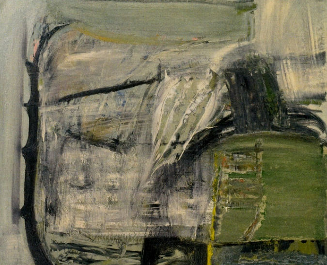
Fig 1 Bird Wind, Peter Lanyon (1955)
Skomer: rabbits and vegetation
Skokholm: a scientific outpost
Coming to Islands
My first view of Skomer was in the autumn of 1969, a decade after it had been declared a national nature reserve. Looking to the west from the mainland across a misty, rainy, Jack Sound from the shelter of the coastguard hut at the top of the Deer Park, I was fascinated by a group of several hundred diving gannets, a reinforcement of the feeling of being immersed in a powerful local wildness. Looking to the south west I could see the island of Skokholm, a small smudge on the gray horizon. Skomer’s nearness is deceptive, although only just over a mile as the crow flies from Martin’s Haven, it could take two men rowing up to three quarters of an hour to reach Welsh Way, which was the southern point of access until North Haven was made accessible by the Victorians and their dynamite. This day, on a rare borderline between humankind and nature, began a mindful intellectual link with Skomer, which has lasted to the present day.
Islands occupy a significant space in the human mind because they are good places to think with. They are good places with which to think because they are more than scenic locations. Their natural boundaries help shape and contain narratives. In my case they are places where poetry and contemplation happen, and I was in search of somewhere to link these powerful social expressions of human wellbeing by making connections between ecology and culture. Up to that time my scientific career had been based on reductive concepts that came from the biochemical laboratory. I was in search of the bigger, but not too complicated, outdoor picture of evolution. This shift in outlook began during the mid 1960s in Sheffield, where I was Reader in Endocrinology and Metabolism. The change in mindset emerged during the co-supervision of a PhD project into how freshwater shrimps could survive in the tidal estuary of the River Esk at Whitby. My new scientific outlook came into a much sharper focus when I was offered a place on an international team studying the physiological survival strategies of animals living at the boundary between the River Amazon and its largest tributary the River Negro. Our base was the spot where, a century before, a pair of British naturalists and explorers, Henry Bates and Alfred Russel Wallace, had located their expedition. When Bates arrived home in 1859 after a full eleven years, he had sent back 14,712 species, mostly insects, of which 8,000 were new to science. From these findings Bates gave the first scientific account of mimicry in animals. The scientific continuity embedded in this small spot on planet Earth was sometimes overwhelming.
Bates and Wallace had begun to explore the Rio Negro or “Black River,” and noticed that the water seemed darkly stained, like tea or coffee. Similar, smaller rivers can be found across the northern Amazon basin. Such rivers are usually deep, slow-moving, and wind through peaty forests or swamps. Where the blackwater of the Rio Negro meets the silt-laden, “whitewater” of the western Amazon Basin, the transition is sharp and visible from space. Our research soon revealed this was an amazing juxtaposition of two entirely different outcomes of evolution expressed in food chains and survival mechanisms This distinct river ecologies also determined diverse cultures of the rivers’ native settlements, which set seeds of cultural ecology in my mind.
The new mindset that was emerging from contact with the diverse tropical rainforest was a response to the fact that educationalists generally do not face “nature” as a whole as an objective and invariant reality, but only in its parts. The reality I had been taught to perceive always implied an isolated subjective and variable component. In truth, the operational reality of the living world can only be systematically and gradually perceived by enlarging its systems and differentiating their elements and relationships. Systems thinking with mind maps is therefore a necessary tool for human progress on an overcrowded planet. It implies both analytical and synthetical processes and thus is sometimes called a “holistic approach” to nature. Education is not something to keep in closed conceptual boxes, even when the box is classroom-shaped. The habit of learning, an urge to find out more, is developed when we feel inspired. The world outside the lecture room is richly inspiring, constantly re-energising what takes place within. It is the source of all our learning: about our history, about our culture, about our place in the natural world and our relationships with each other. This two-way flow can be embedded in every child’s education, entirely at ease within any age group and any teacher’s ethos. Sadly an out of date European education system devised to establish and exploit empires gets in the way.
Sheltering from the weather on the edge of the world, watching the primeval interaction of predator and prey, I needed poetical inspiration to express the wild reality in front of me, which could describe and transmits ecstasy while retaining a practical awareness of the world as a system that goes on relentlessly driven by interlocking food chains. It was not until 1992, the year of the world summit to launch a strategy to save the planet, that the American poet Mary Oliver captured my mood of 23 years ago, when I vowed to bring students to this place where they could determine for themselves their place in nature.
The depiction of Skomer in its wildness was the aim of the Welsh painter, Rosemary Howard Jones. Rosemary, known as “Ray”, grew up near Cardiff and on a visit to Pembrokeshire as a child fell in love with the coastline that was to hold and sustain her throughout her life. In the 1950s she spend long periods on Skomer living in the ‘Rabbit Catcher’s Hut’, with her long-term partner, photographer Ray Moore. The hut had basic furniture the pair had made from driftwood. I remember discussions with her about the merits of the interwar poets in her silver caravan permanently parked just within the gate to the Deer Park when she was regarded a rather eccentric recluse, Another image is of her sitting gross legged in the prow of the boat going to Skokholm, drenched with spray, anorak turned up, sketching the breaking waves around her.
Thinking with islands
Quite remarkable things happen when itinerant people set foot on small islands. Small is beautiful but small is also vulnerable so resilience and adaptability have to be the order of the day,
Skomer: a timeline
Skomer is a small cliff girt, treeless, island situated about a mile off the coast of South West Wales. In terms of its function as a human natural resource its history goes back to the migrations of the first prehistoric farmers. From this time to the present there has been a varying human presence in a long story in many episodes lasting lasting thousands of years or just a few hours. Evidence for long term social dynamics rests with the development of field boundaries, where denuded plough lynchets and remains of stone walled fields show clear phasing among overlapping farming systems, all indicative of a complex cultural past.
Present day visitors are taken on a tour of the roofless round houses and their associated field systems which have been dated to the Iron Age. The evidence comes from excavations at a prehistoric mound of burnt and fire-cracked stones once used to boil water for cooking. This has produced calibrated radiocarbon dates of between 751-408 BC, A cattle tooth deposited in the cooking mound was dated to around 85 BC.
Speculations about an even earlier culture have focused on a barrow associated with a considerable number of cairns. There is also evidence for possible megalithic structures. This would date the first human settlement to the of Neolithic or early Bronze Age. It is claimed that among these remains are at least three standing stone pairs which raises the possibility that they represent a small ritual site. This idea chimes with the latest ideas of the migration of Neolithic henge builders who spread from Orkney to Salisbury Plain, taking a route south along the western coastline of Britain. The bluestones, which mark an early conceptual stage of Stonehenge, were quarried a relatively short distance from Skomer and this positions the island within the epicentre of a ‘standing stone’ culture which transferred key cultural elements from Pembrokeshire to Salisbury Plain.
The first documents on Skomer appear in the mid 14th century when the island was established as a large rabbit warren. A set of accounts recording this operation was compiled by the Norman administration of Haverford West, where the island was an extension of the castle’s community of St Martins.
It seems that the island was uninhabited during the medieval period except for the seasonal visits of warreners and cattle farmers.
The ruined farmhouse, and surrounding large rectangular fields that now dominate the centre of the island were erected in the 1840s by the mainland owner as an investment for the rental market. The returns from agriculture were probably marginal and over the years the island came to be valued more for its exceptional wildlife. This phase culminated in Skomer being declared a national nature reserve in 1959. It is now staffed by a manager and volunteers of the Wildlife Trust of South and West Wales. Old farm buildings have been converted as visitor accommodation and there is a daily boat service most of the year. There is a house for the manager to which is attached a small laboratory with accommodation for field workers. However, my first visit to Skomer predated these comforts. The boat was unpredictable, boarding was either direct from the beach or a convenient rock face and the accommodation was primitive.
Skomer: rabbits and vegetation
A broad scientific framework for understanding the natural history of Skomer was established in a report of a seven month long expedition to survey the island, organised by the West Wales Field Society in 1946. At that time Skomer was emerging from a period during the war when rabbits had been culled in a semi-agricultural system and the central fields had been lightly grazed by a few cattle and sheep . Short rabbit nibbled floriferous pastures dominated the landscape, which were described as being springy and pleasant to walk over.
The principal vector of myxomatosis in Britain in 1954 and 1955 was the rabbit flea, Spilopsyllus cuniculi. Rabbits remained numerous on the island of Skokholm where they were free from fleas, but nearly all were destroyed on Skomer. When I first set foot on Skomer in 1971, the rabbit population was subject to a year on year cyclic rise and fall as myxomatosis had begun to equilibrate with its rabbits and their fleas. From an island that in 1957 had been lush with grass it was returning to a more patchy landscape dominated by common rabbit resistant plants . In the late 1960s the springy turf had been reduced to a very thin covering, with many mossy patches and bare ground. The turf was no longer thick enough to feel pleasant underfoot. Because rabbits live at a such a high density, up to 40 per acre on Skomer, every part of the island, apart from the cliff ledges inaccessible to them, was affected by their burrowing, trampling, scraping, defecation and grazing. There were fears of soil erosion, particularly on the western cliff tops, where nesting burrows of shearwaters and puffins were at risk.. Also, there were several large expanding gull colonies in the centre of the island feeding on household food waste available on mainland rubbish dumps.
As a result of discussions with the staff of the Nature Conservancy Council who were managing the island, it was agreed that I should evaluate the idea of an imminent erosion threat. This would involve undergraduates from my department spending two weeks on Skomer in long term group work on the impact of rabbits and gulls, but they would also have their individual self motivated projects that would throw light on the ecological dynamics of other species and give them a taste of what real scientific thinking was about. For the first few years of this work the Cardiff student group was based in the ‘Rabbit Catcher’s Hut’ at the farm..
Long term effort was required because everyone recognised that ecological processes occur and interact at various spatial and temporal scales that require long periods of surveillance to detect and evaluate. In contrast, most ecological research occurs over short periods of time and is limited in its spatial extent, restricting our understanding of longer-term and broader-scale processes. The resulting gaps in our ecological knowledge are sometimes labelled the “invisible present” and the “invisible place”. Without baseline data to provide a reference it is difficult to infer what long-term changes may be occurring and whether short-term local studies are representative or merely anecdotal. Although top-down effects of particular herbivores and carnivores at the landscape level are now well-recognized, these have generally been demonstrated to occur locally and over short periods of time. Importantly, we now have ample evidence that herbivores such as rabbits and deer can dramatically affect plant communities derived from fenced exclosure studies, island studies, and direct observation. Nevertheless, doubts and uncertainty persist concerning whether such long term impacts are serious or pervasive and how long they persist.
It turned out that Skomer’s gull problem was a temporary one and by 1985 the number of breeding pairs had dropped to about 10% of the 1960s peak. Regarding rabbits, looking back three decades we can now see that the catastrophic effect of myxomatosis on Skomer had set in motion long term ecological forces expressed in repeated cycles of plant succession. This produces a fairly predictable surface mosaic related to the rise and fall in the rabbit population, punctuated by rare winter inundations of the island by gale-born salt spray. Regarding weather, the log of the 1946 expedition to Skomer recorded a severe September gale that snapped bracken stems about a foot from the ground, withering vegetation well into the centre of the island.
Looking back, these relatively short lived grassland microcosms characteristically appear and disappear in cycles of plant succession, occupying decades and take place alongside population trends in longer lived colonies of bracken and heath. At any time the botanical patchiness of Skomer is revealed as a dynamic mosaic of microcosms, with long and short periods. The longer trends, particularly in heathland, are possibly the outcome of local climate change.
The above conclusions have come from a few sampling sites representative of unenclosed cliff tops and the large central fields. However, the island has been compartmented by generations of prehistoric farmers eking out a living from a relatively small space. Aerial surveys have shown that this has resulted in a complex pattern of small enclosures now only visible at ground level, which extend below the much larger Victorian enclosures. This raises the question as to what extent this prehistoric field pattern is influencing the current pattern of vegetation. Phosphorus is unique among the elements in being a sensitive and persistent indicator of human activity. It has long been of interest to archaeologists because of its potential to inform them about the presence of past human occupation and to offer clues regarding the type and intensity of human activity. In particular several properties of phosphates lead to long-lasting residual ecological effects of phosphate used for crop fertilization. Phosphorus occurs in the soil in several different chemical forms, most of which are relatively insoluble in water, sensitive to pH changes, and immobile. Soil phosphate can also be grouped into inorganic and organic forms. On Skomer the use of phosphate fertilizer, from manure, is evident in the distribution of stinging nettles Availability of phosphate is the chief factor affecting their distribution and they may be taken as indicators of the effects of prehistoric agriculture. For example, in a small prehistoric rectangular enclosure the vegetation inside can be quite different from that outside. In particular, nettles are found inside but not outside.
Skokholm: a scientific outpost
It was in fact the island of Skokholm, not Skomer, that had first attracted me to Pembrokeshire, with the objective of organising a research project on its colony of house mice. Mice live freely all over Skokholm in a population that had then been in existence for more than 70 years. The ecological genetics of these animals had been studied intensively from 1960 to 1969 by the geneticist Sam Berry, who had set up a small field laboratory on the island for this purpose. At that time I was co-director of the Nuffield Gerontology Laboratory at Hull University and had just been appointed head of the department of zoology in the University of Wales at Cardiff. The aim of my research on Skokholm was to investigate to what extent studies on laboratory animals could be extended to animals in the wild. Put simply the question is, do mice in the wild age in the same way as mice bred in the laboratory?
The other important historical feature of Skokholm that had brought me to this part of South Wales, was the significant position of the island in the the development of the science of ecology. The key local figure was Ronald Lockley, a farmer and naturalist, who took a lease on the island and began from 1928 to study migratory birds using the ‘new’ technique of ‘ringing’. He established the first British bird observatory on Skokholm in 1933, One of its early pieces of research was Lockley’s work in 1936-7 with David Lack on the homing behaviour of the Manx Shearwater. Their ringing experiments showed that this bird, which nests in large numbers on Skokholm, can successfully return to the island from great distances. This involved taking birds to Venice!. The farthest distance of Skokholm from Venice, is about 930 miles direct, while if this bird travelled the whole way back by sea it must have covered at least 3,700 miles.
The other important biological principle that arose out of discussions among the many ornithologists who visited the bird observatory in its early days, led to David Lack’s ruminations on the fact that islands demonstrate that, the smaller and more remote the island, the more impoverished the bird fauna compared with the mainland. This is possibly the most general pattern found in ecology, and many explanations have been proposed. The relationship between island area and number of species is now well known: larger islands contain more species than smaller islands. Furthermore, “Islands” can be used to refer not only to pieces of land surrounded by water, but to habitat islands as well, such as lakes, forest fragments, etc.
Regarding my work on the ageing of Skokholm’s wild mice, which was carried out in the early 1970s, individuals were allotted to eight age-classes on the basis of tooth wear, such that the oldest group were over a year old and had survived the previous winter, while the others had all been born in the current breeding season. This gave a maximum life span of a year. In the laboratory, these mice lived, as do laboratory mice, for a maximum of around three years.
Molecular markers showed that natural selection was operating on the wild Skokholm mice, so that the age groups were not genetically homogeneous. Animals living a few metres apart were different genotypes. A number of characters were shown to be age-correlated, and their importance varied in mice from different habitats; no one trait could adequately describe the observed changes with age. The conclusion is that ageing studies carried out on ‘standardized’ laboratory animals in a necessarily over-simplified experimental environment may give results misleading to gerontologists. Human ageing does not occur in the wild because individuals die of disease or predation before they can experience it.
Rabbits are the other small mammal living wild on Skokholm, and Lockley, in his capacity of farmer, engaged with them as a pest that was frustrating his efforts to make the island pay as a commercial enterprise. In this connection he adopted every new pest control system that was developed to exterminate them. So it was that Sir Charles Martin brought the virulent strain of the virus known as Myxomatosis cuniculi to the island. In his choice of Skokholm Sir Charles had decided that the possibility of the virus being carried from Skokholm to wild rabbits elsewhere was too remote to constitute a public danger. He made three separate attempts to induce myxomatosis in Skokholm rabbits in 1936, 1937 and 1938. Although in each attempt the rabbits inoculated with the virus appeared to have died within the usual period of less than fourteen days, there was little or no spread to uninoculated rabbits. The result of the Skokholm experiment was to dismiss any use of the virus as a rabbit control measure.
However, in October 1953 myxomatosis’ was introduced into south-eastern England by unknown means and was first notified in October 1953. Attempts were at first made to eradicate it, but it spread and was established at twelve places in the south-eastern counties by the spring of 1954. It was recorded from Wales in May and from Scotland in July, its spread in these cases having undoubtedly been helped by the transfer of diseased rabbits to uninfected areas. Most of England and Wales south of a line from the Wash to the Wirral peninsula was affected by the end of 1954, and every county in northern England had some infection. Deliberate spreading of the disease by transfer of infected rabbits was made an offence in November. Virulence remained high, generally with a mortality of about. 99 per cent., through 1955, and the disease was present in most parishes in Great Britain by the end of the year. After an epidemic, which killed up to 99% of mainland animals, sporadic cases continued to occur among the depleted population to the present day.
Bird’s-eye landscapes
The artist Kazimir Malevich (1878-1935), who wrote extensively on the aesthetics and philosophy of modern art, identified the aerial landscape (especially the “bird’s-eye view”, looking straight down, as opposed to an oblique angle) as a genuinely new and radicalizing paradigm in the art of the twentieth century. In his view, air travel, and more specifically, aerial photography had created this broad change in scenic consciousness. The Italian Futurists were similarly fascinated with aerial views of landscapes.
Unlike traditional landscapes, aerial landscapes often do not include any view of a horizon or sky, nor in such cases is there any recession of the view into an infinite distance. Additionally, there is a natural kinship between aerial landscape painting and abstract painting, not only because familiar objects are sometimes difficult to recognize when viewed aerially, but because there is no natural “up” or “down” orientation in the painting..
The Cornish painter and glider pilot, Peter Lanyon, imagines being hundreds of feet above the Penwith Peninsula as a bird, wings spread, with wisps of cloud, and fields and hedges far below represented in a style that straddles the figurative and the abstract (Fig 1). Another interpretation of this painting is that it is a personal body of interdisciplinary knowledge about Cornish cultural ecology situated to the south of St Ives.
It is only recently that science and art have come together in the presentation and analysis of the surface landscape. The methodology and evidence is that of aerial survey. The first aerial photograph to obtain geographical information was taken of a French village and its surroundings in the late 19th century. The man who took the picture was photographer Gaspar Felix Tournachon. He patented the concept of using aerial photographs to compile maps. The invention was to prove much more effective than the time-consuming ground surveys that had then been used by national mapping organisations that developed throughout the 19th century. George R. Lawrence took aerial photographs of San Francisco in 1906 following the devastating earthquake, but it was not until World War I, when potentially military applications were foreseen, that a systematic process of taking aerial photographs would become key to the development of the photographic method for obtaining environmental information. Archeology has gained the most from its application to reveal buried remains of earthworks and buildings.
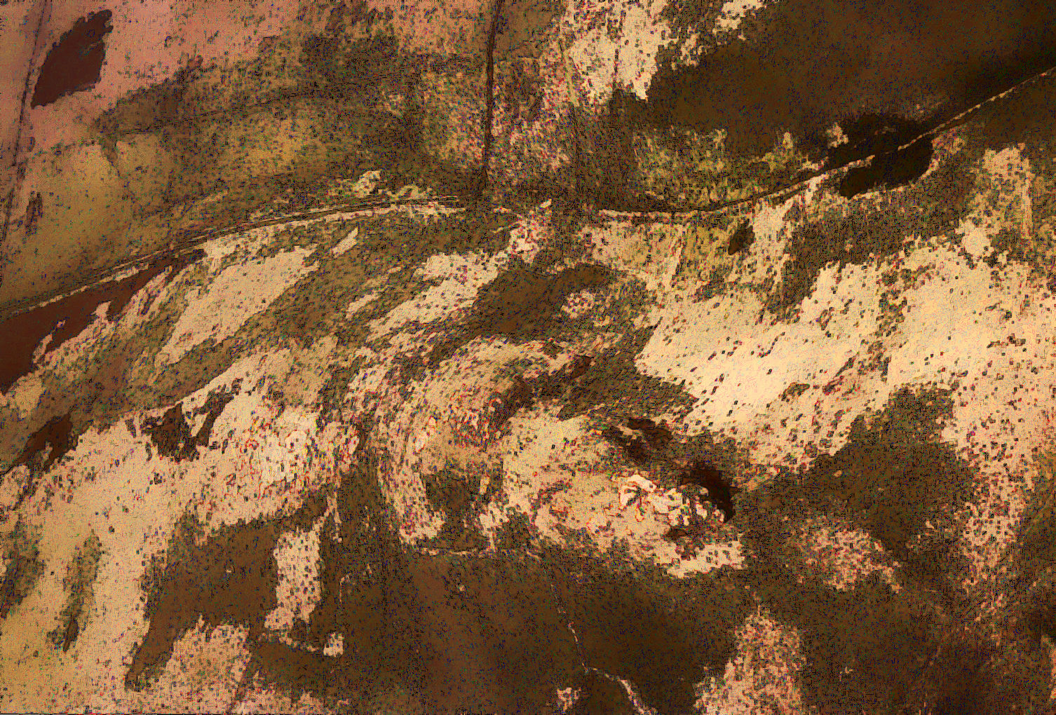
Science meets up with art in digital technology, when an artwork is produced from an aerial photograph taken in an ecological survey. (Fig 2).
Fig 2 Skomer: ‘photoshopped art’ from snapshot of grassland taken from helicopter
Mapping ecosystems
As the largest terrestrial ecosystem on Earth, grassland is also associated closely with many of the most challenging environmental and ecological problems that humankind will face during the next several decades, at a global scale. These include desertification, land degradation, climate change and loss of biodiversity. It is vitally important that better long term temporal inventories are obtained of grassland and that improved surveillance and monitoring with relative accuracy takes place, so that sustainable, long term grassland management is achieved. However, due to its great expanse and diversity, rapid and low-cost evaluation and management techniques are required. For this reason, remote sensing technology provides a powerful tool for producing an inventory, managing it and monitoring outcomes.
Remote sensing has been recommended for at least 30 years for use in the management of grassland resources on a worldwide basis. The first black and white aerial photography became available for investigating grassland as a resource in 1935. Remote sensing developed into a science in the mid to late 1960. The launch of Landsat 1 in 1972 ushered in a new era extending remote sensing beyond air photo interpretation into the realm of digital analysis of multispectral and multitemporal data. A literature survey shows that 407 papers in grassland remote sensing were recorded by the CABI information database from 1995 to 1999.
The application of remote sensing technology covers land classification and changes in grassland-use, grassland productivity-assessment, conservation and recreation, detection and monitoring of stress caused by fire, drought and pests. Today, remote sensing, along with Geographic Information Systems (GIS) and Global Positioning Systems (GPS) have provided a powerful and sophisticated approach to the utilization, development and management of grassland resources throughout the world.
Skomer microcosms
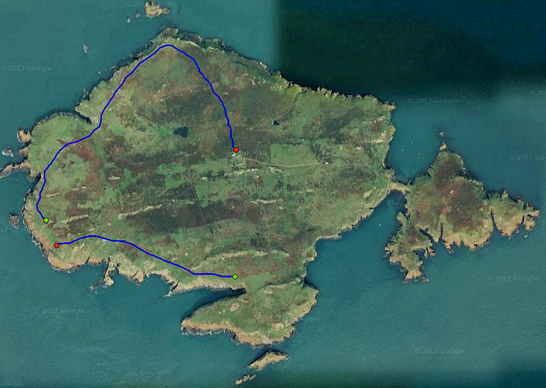
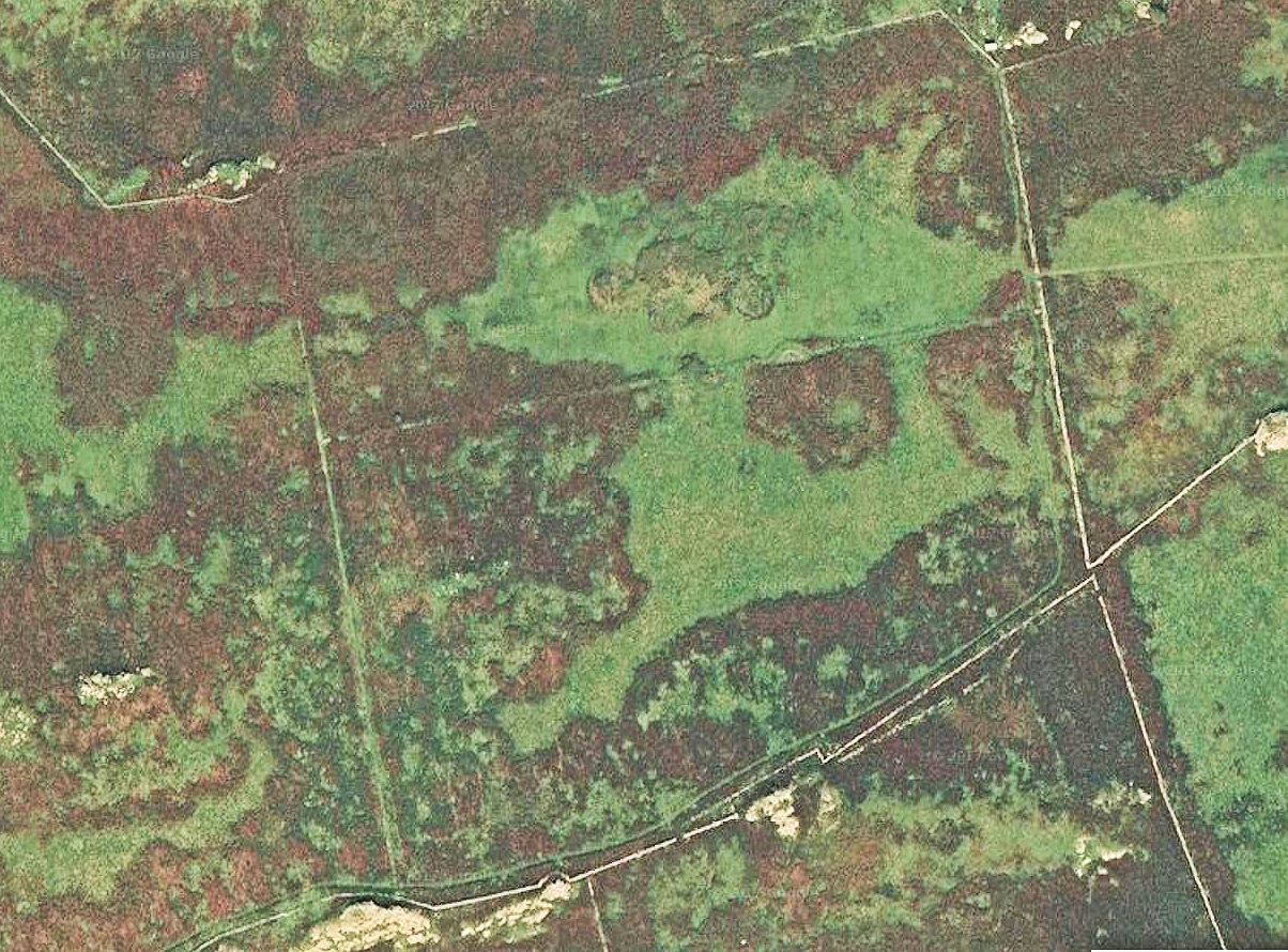
The vegetation of Skomer Island was first surveyed on the ground and presented as a bird’s eye view of the surface of the island in 1947. The map makes a scientific statement that the ground cover was about equally shared between sub maritime grassland and dense stands of bracken with small areas of heather heath (Fig 3). From the mapped distribution of these habitats bracken seems to be more dominant in the north east of the island with grassland more common in the south west. A glance at the current Google satellite image suggests that the distribution of these two habitat features has changed little in the last 70 years (Fig 4).
Fig 3 Ground survey of vegetation 1947
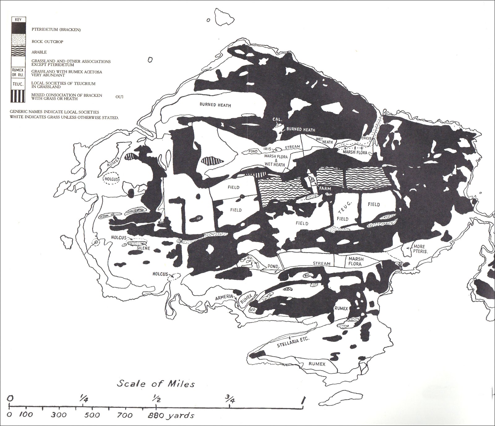
Fig 4 Skomer: Google satellite image, 2017
Within a global context, the treeless island of Skomer has been classed as a Western Eurasian Thicket, maintained dynamically by a combination of south westerly maritime air flows and heavy rabbit grazing. In the classification of Palaearctic habitats Skomer may be described holistically at the present time as an arrested succession towards Atlantic Blackthorn/Bramble Scrub. The bìg question is how bracken heath and grassland have coexisted in a dynamic equilibrium for such a long time without management. This question will be answered through long term aerial surveillance of the vegetation patchwork to assess the stability of patch boundaries and the life strategies of the plant species in border microcosms.
Table 1 Common plants of of the Skomer microcosms
| Species | Common name |
| Calluna vulgaris | Ling Heather |
| Holcus lanatus | Yorkshire Fog |
| Silene dioica | Red Campion |
| Glechoma hederacea | Ground Ivy |
| Teucrium scorodonia | Woodsage |
| Armeria maritima | Thrift |
| Silene maritima | Sea Campion |
| Rumex acetosella | Sheep’s Sorrel |
| Endymion non-scriptus | Bluebell |
| Matricaria maritima | Scentless Mayweed |
| Agrostis/Festuca community | Rabbit occupied grassland |
| Arrhenatherum, elatus | False Oat |
Because it is only about two miles wide and relatively flat, Skomer is an ideal habitat for aerial surveys, which can easily be truthed as microcosms on the ground. In this context the production of the 1947 vegetation map by J. Sadd is a remarkable achievement. It delineates the island as a botanical patchwork of ecological compartments comprising about a dozen common plants (Table 1).
Fig 4 Skomer:topographical compartments
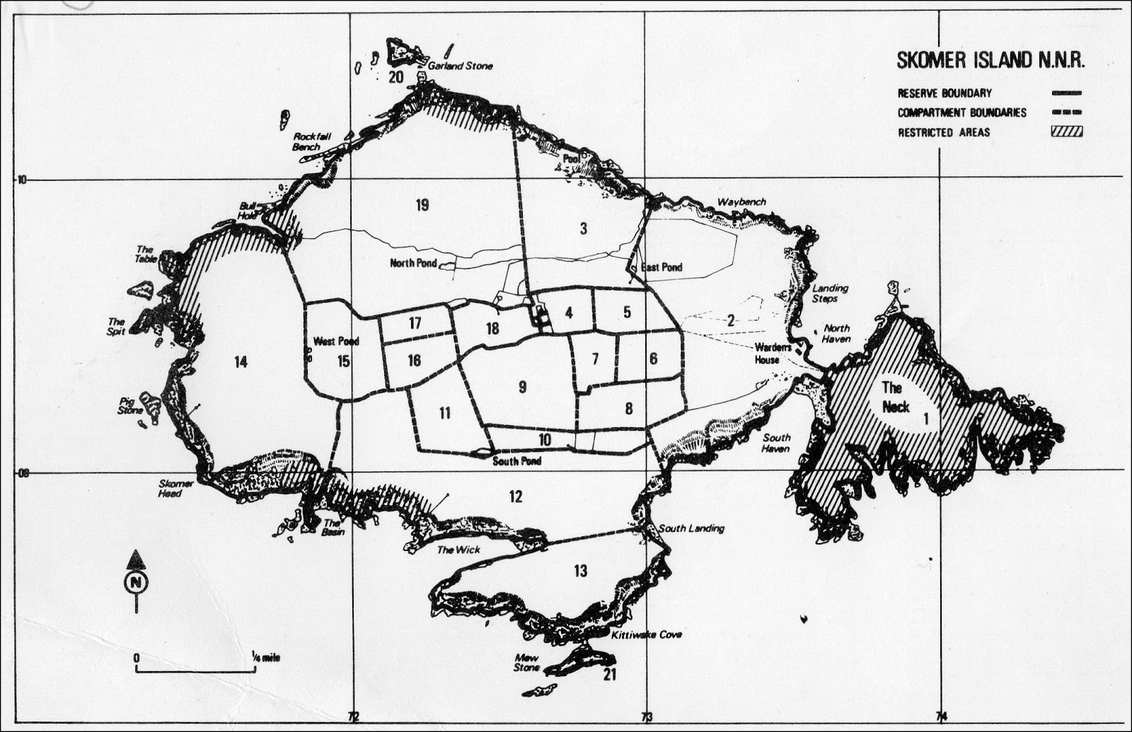
The ecological compartmented microcosms have been simplified to produce a map of 20 topographical divisions for locating observations and projects (Fig 4). In the centre of the island these divisions coincide with the fields laid out in the 19th century to create a ‘modern’ farm linked with the mainland economy. At the time of Sadd’s survey the commercial farming enterprise was utilising the central fields to grow early potatoes for the mainland market. This venture provides a baseline of zero biodiversity for at least three of the fields (compartments 4,5, 6, & 18) from which their present wildness has developed over the following six to seven decades.
It is probably significant that Sadd records areas of burnt heath north of the farm. This is indicative of management of heather for livestock grazing. It is known that cattle grazed the outer regions of the island at this time, and Sadd mentions there were also sheep and goats.
Walking round the island today, it doesn’t take long to recognise that some of the local botanical patchwork is related to geological features. Persistent grassland often occurs in the immediate vicinity of rock outcrops. It also becomes clear that human activity has produced subtle ecological patterns and that some of the impacts have been transient. The was the case for Compartment 8 in the 1970s, where grassland ridge and furrow had been colonised by heather. It flourished along the drier ridges but was absent from the wetter furrows. Over the next decade or so the heather was displaced by bracken, a trend that instigated a management reaction aimed at protecting the incipient heathland from rabbit grazing. In retrospect, it can now be seen that bracken invasion, not rabbits was the culprit. Now, bracken and heather exist together.
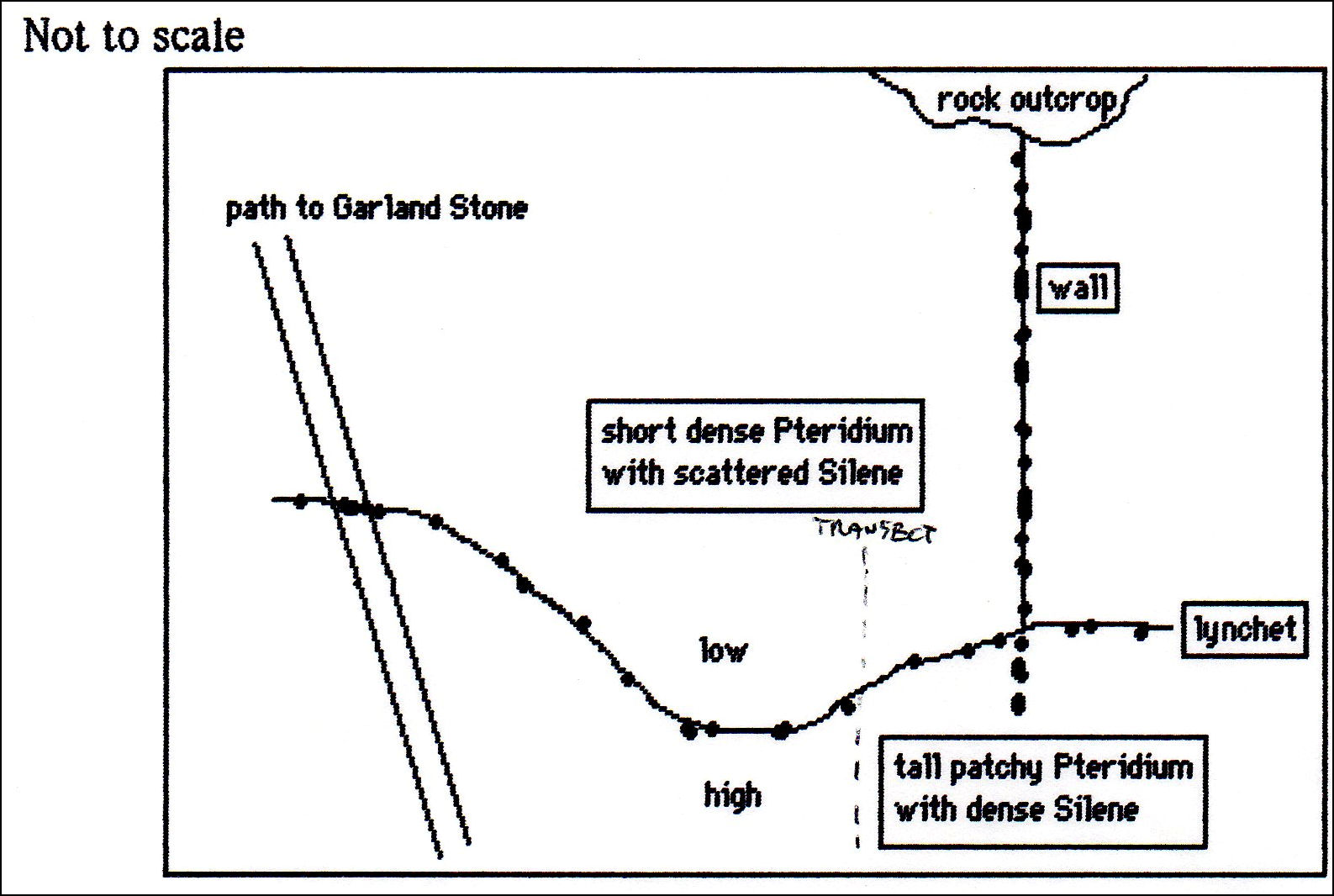
Today one often comes across ecological differences across man-made boundaries, recorded as the loss of species or changes in their relative density (Fig 5). For instance, there are patches of nettles alongside hut circles. Scatterings of nettles are also found in some small prehistoric fields. Nettles are evidence of soil phosphate, which originates from waste disposal and livestock dung. Are these the outcomes of the behaviour of prehistoric farmers that have persisted as local differences in soil chemistry for thousands of years?
Fig 5 Differences in density of Red Campion and Bracken across a prehistoric lynchet south of the Garland Stone (1980: Compartment 3)
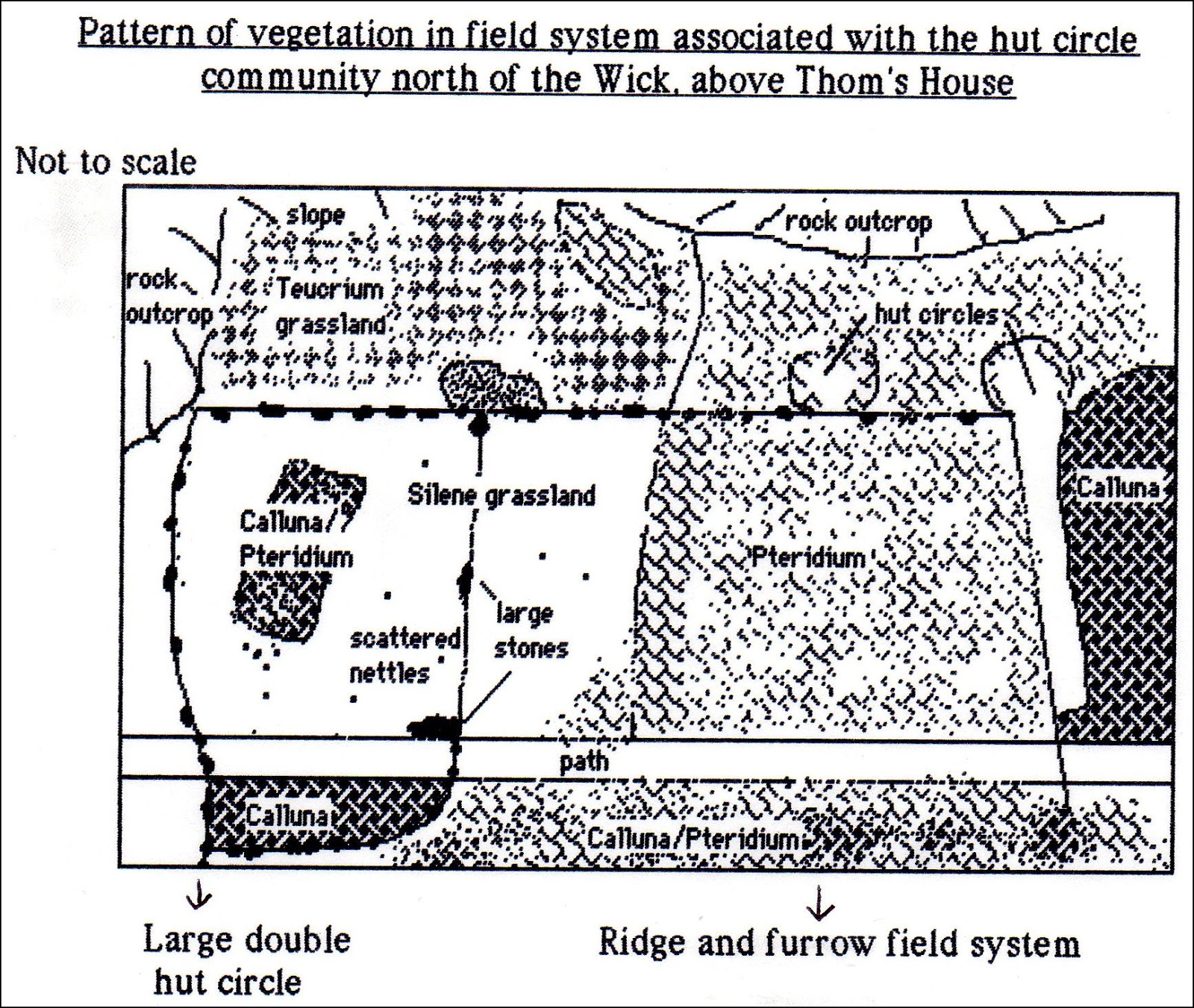
In the 1980s good examples of small scale patchworks could be observed in Compartment 12 (Fig 6).
Fig 6 A diverse botanical microcosm (compartment 12, 1987)
With the advent of satellite mapping the patchiness of bracken in grassland was obvious in the 2017 Google map of Compartments 16, 17 & 18 (Figs 7 and 8).
Fig 7 Compartment 16 (Google satellite map, 2017)
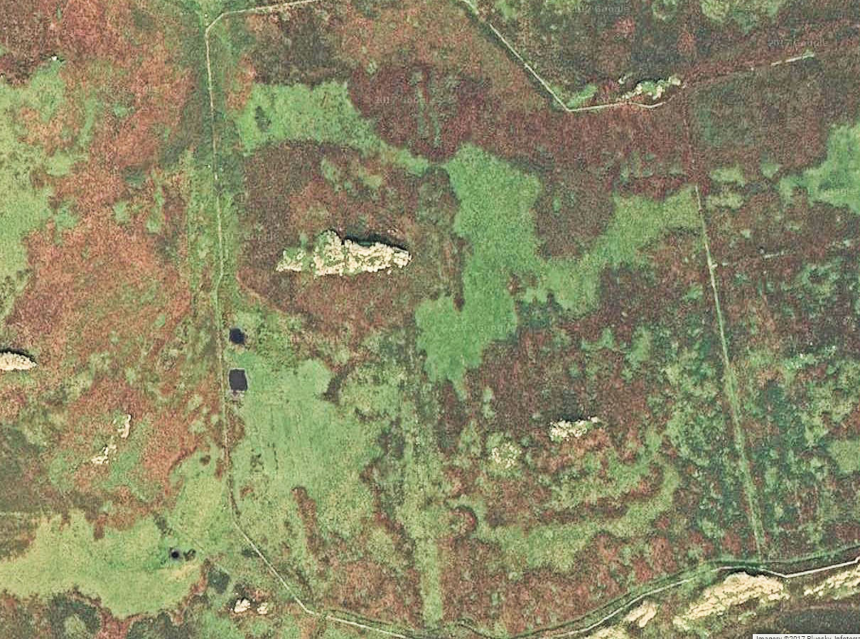
Fig 8 Compartments 17 & 18 (Google satellite map, 2017)
Regarding ground truthing, the National Vegetation Classification (NVC) is one of the key common standards developed for nature conservation agencies that takes a macrocosm view of botanical diversity. The original project aimed to produce a comprehensive classification and description of the plant communities of Britain, each systematically named and arranged and with standardised descriptions for each. It was originally commissioned in 1975 by the Nature Conservancy Council (NCC) and was intended as a new classification, not an attempt to fit British plant communities into some existing scheme derived from elsewhere in Europe. The general approach adopted was phytosociological and, therefore, concentrated on the rigorous recording of floristic data. It did, nevertheless, try to avoid over-scrupulous selection of samples, rejection of awkward data and preoccupation with the hierarchical taxonomy of vegetation types Quadrats are used to collect data on the abundance and frequency of each plant species. This information is then analysed using NVC community/ sub-community descriptions. Each NVC habitat type then uniquely defines a macrocosm as a particular statistical combination of frequency and abundance values.
A quadrat-based approach was applied to survey Skomer’s vegetation in 1979 based on a random distribution of 270 sampling sites of which 90 were made permanent. The plants common to this survey are listed in Table 1.
The results did not fit any of the NVC categories, which was to be expected because there was no rejection of awkward data and the averages do not match the obvious patchwork perceived visually as local high levels of diversity produced by the activities of rabbits. In 1998, 76 of the quadrats were re-surveyed for the six main species and 13 were analysed in 2015. Due to time constraints and the fact that the position of most plots is unknown, only 13 were surveyed in 2015. Much time was spent searching for the plot markers. Because of the small numbers of quadrats that were actually found no firm conclusions were possible regarding temporal trends in species abundance. This testifies to the futility of trying to organise long term surveillance by positioning quadrats on a map without precise grid
Therefore, there is only anecdotal evidence as to long term changes in the surface landscape. In this context, there has been a great loss of maritime heath. Up until the last farming episode on Skomer in the 1940-50s maritime heath had been maintained by a combination of grazing, probably by sheep, and periodic burning. These operations were likely to have been managed at relatively low densities of rabbits, which had always been controlled by owners and tenants by shooting and trapping them. Sadd only mentions the impact of rabbits when he described Compartment 9, which was definitely not grazed by farm livestock.
The abolition of the livestock production system and the banning of rabbit culling when the island became a nature reserve is likely to have been responsible for the gradual loss of heathland. In recent years climate change may also have played a part.
Previous studies
The following changes in vegetation have been investigated by students of Cardiff University from the 1970s to the 1990s.
Periodic, short lived population explosions of a range of common plants. These include Sheep’s Sorrel, Scentless Mayweed, Red Campion and Ragwort. These are weedy biennial species with seeds that are stored in the ground to germinate when
The main findings of the cardiff work are discussed in the following report.
Relationships Between Vegetation and the Population Dynamics of Skomer’s Rabbits
Drone survey
Drone technology is increasingly being used for scientific research. It has a wide range of applications, for example in agriculture, coastal erosion, animal tracking and land-use. It is increasingly being used, alongside satellite images and fixed point photography for botanical research. It is a developing area with applications being trialled and refined, taking advantage of the high resolution images that can be captured. This project aims to determine the efficiency and accuracy of surveying the seasonal and long term dynamics of the Skomer’s botanical patchiness integrating drone photography with conventional ground techniques of transects and quadrats.
Skomer macrocosms
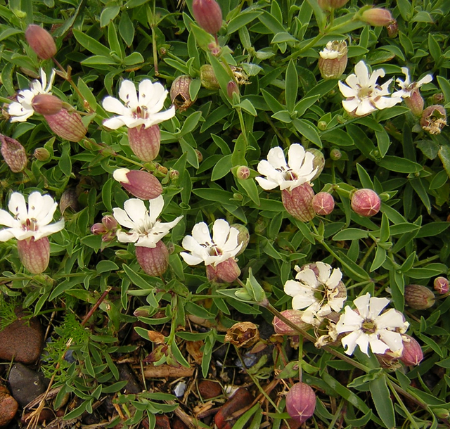
Sea Campion
1 Rationale
Research into the population dynamics of the Sea Campion (Silene maritima; now renamed Silene monoflora) was started by Prof Denis Bellamy in the 1970s as part of a long term effort to understand the influence of rabbits on the vegetation and soils of Skomer’s coastal slopes. At that time, rabbit grazing and burrowing had resulted in cycles of bare ground being colonised by a sequence of Sea Pink (Armeria maritima),Sheep’s Sorrel (Rumex acetocella) , Yorkshire Fog (Holcus lanatus ), Scentless Mayweed (Tripleurospermum maritimum) and Sea Campion . These cycles peaked with dead vegetation (usually Yorkshire Fog and Bent), which was then colonised unpredictably by the species next in succession. It was clear from quadrat analysis in many parts of the island, that these cycles had periodicities of several years and were profoundly influenced by occasional strong South Westerly gales, which were powerful enough to uproot bracken in the centre of the island. Two other species have population explosions on Skomer related to rabbit numbers both of which have a dramatic scenic inland impact. These are Ragwort (Senecio jacobaea) and Red Campion (Silene dioica) ; the most recent being in 2015 (Figs 1 and 2l).
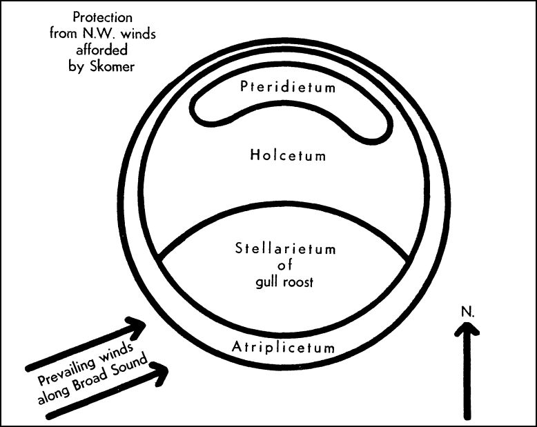
It is the winds swirling around the West coast of Wales that are the major physical factors that determine the pattern of island vegetation. Their effects are summarised in the ecological snapshot of vegetation on Middleholm, the tiny island between Skomer and the mainland, as it was six decades ago (Fig 3). A south to north gradient of decreasing impact of south westerly weather determines a botanical gradient from grassland to bracken. The actual species in this gradient are determined by the impact of gulls (Common Chickweed (Stellaria media)) and rabbits (Yorkshire Fog (Holcus lanatus)).
Fig 3 Diagrammatic representation of the vegetation on Middleholm (Gillham, 1956)
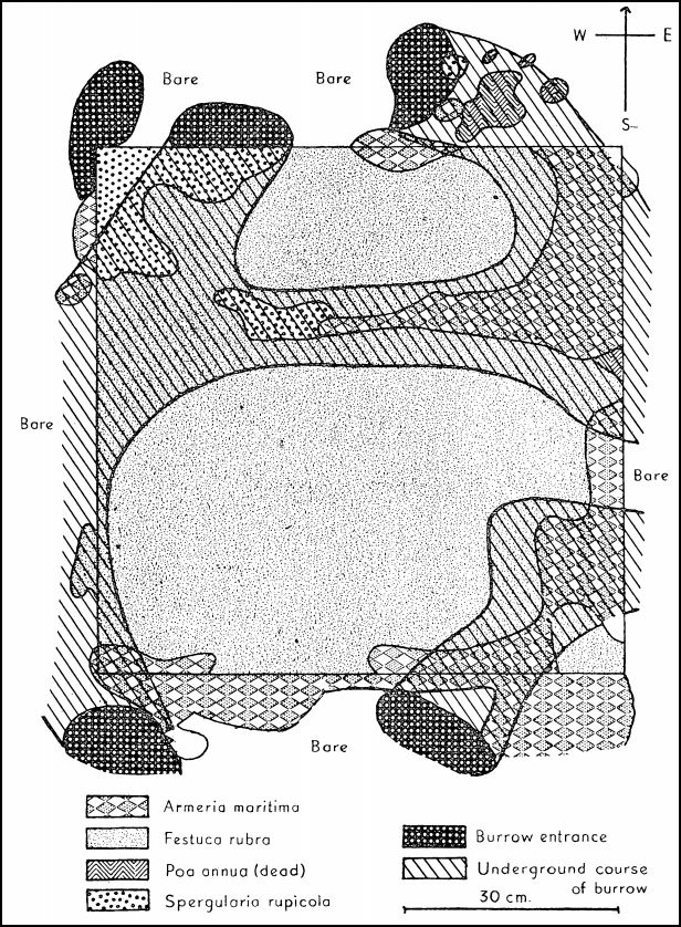
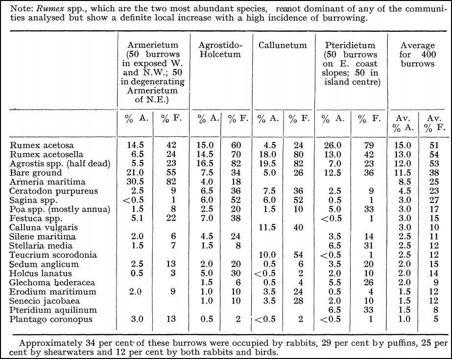
By the 1980s on Skomer, at the Wick and North of Skomer Head, the peaty soil of the coastal slopes had been stripped down to bare rock. A rabbit exclosure at Skomer Head showed dramatically the difference that unchecked rabbits had made. Inside, there was a 0.5 metre deep development of a monoculture of fescue peat (Festuca rubra), which contrasted with the surrounding bare soil, rock and the patchy colonisation by the rabbit avoided species listed above. Several Shearwaters had burrows inside the exclosure highlighting the fact that rabbits had destroyed a considerable area of its nesting habitat along this part of the coastal slopes . The fine details of the rabbit burrow microcosm had been defined by Mary Gillham in her research on the nearby island Skokholm in the 1940-50s.
She had placed a rabbit proof exclosure between five burrows in a patch of degenerating Armeria. (Fig 4). Her map depicts a rabbit-proof enclosure in the sixth summer after its erection. Regarding its complex dynamics she says:
“Festuca in the interim had occupied practically the whole area except the north-west corner which was exposed to the prevailing winds and close to a burrow entrance. As the burrow system was extended by puffins and rabbits the Armeria reinvaded locally above its ramifications, and with it the perennial, deep- rooted Spergularia rupicola which is one of its commonest associates in all burrowed areas, although seldom abundant because of its palatability to grazing animals. Rumex species are also able to resist the Festuca in the ungrazed vegetation over burrows, whilst Poa annua, Stellaria media and Erodium maritimum may invade temporarily as the Festuca succumbs.”
Fig 4 The relationship of ungrazed vegetation to the underlying burrows. Rabbit-proof enclosure, N.E. Skokholm, July 1953 (Giillham, 1956).
Gillham’s research on Skokholm, which began in 1948, was mainly concerned with the impact on vegetation of the faecal nutrients from nesting colonial seabirds. Although only a mile away along the coast from Skomer, the island of Skokholm is more exposed to South Westerly air flows and is like a promenade regarding the impact of gale driven waves and salt spray. In this respect, Skomer with its valleys and rocky outcrops responds to weather variations in more diverse ways.
2 Setting the scene
Because of its smaller size and more widespread exposure Skokholm is a good place to model the combined effects of burrowing sea birds and rabbits on vegetation. Gillham defined the island as being dominated by ten plant species spread between four botanical habitats: namely, Thrift, Grass (mainly Yorkshire Fog and Bent), Heather and Bracken (Table 1).
Table 1 Ground cover and frequency of the twenty most important species growing over burrows in the four chief plant communities on Skokholm in order of decreasing abundance (Gillham, 1956).
Silene maritima is an important plant of puffin colonies on offshore islands. In this connection, partial burial of Silene, as occurs after the inundation on shingle banks, stimulates the plants to more vigorous growth to keep on top of the shifting substrate. Regarding puffins nests, this trapping of soil by the Silene stems helps to prevent erosion and maintain the step-like formation of the cliff profile. A small, fairly level area at the burrow entrance is necessary or the birds could not alight. Hence the maintenance of this platform by the Silene is an important factor contributing to the habitability of burrows on the steeper slopes. In the more sheltered puffin colonies of the eastern parts of Skokholm where the burrow entrances give rise to a step-like formation on the steeper earth slopes, the Silene tends to occupy the untrodden brinks of the vertical faces.
These ecological features of led to the idea behind an in depth study Sea Campion as a potential candidate for managing the process of soil erosion by extending its vegetation cover using clonal transplants on Skomer’s eroding coastal slopes. Work was therefore needed to define its variation, reproduction and growth. This involved measurements being made on the island and the collection of seeds for mainland studies.
In addition, this is a classic species for research on plant reproduction. Originally described by Linnaeus, members of this genus have been the subject of research by plant ecologists, evolutionary biologists, and geneticists, including Charles Darwin and Gregor Mendel. Many Silene species are widely used scientific models, particularly in the fields of ecology and evolutionary biology. Thus, studies on the Sea Campion would bring this fundamental botanical work to a focus on Skomer as an outdoor laboratory and an educational resource for the study of conservation management.
The ‘campions’
‘Campions’ is the common name for the genus Silene, which worldwide is composed of around 700 individual species including annuals, biennials and perennials. They occupy a variety of habitats such as meadow, woodland, mountain, coastal slopes and metalliferous waste tips. The genus has colonised Asia, Europe, Australasia and the Americas. Recently, S. latifolia has become an invasive pest in North America where it was introduced around 200 years ago.
Silene species commonly contain a mixture of hermaphroditic and female (or male-sterile) individuals (gynodioecy), and early studies by Correns showed that male sterility could be maternally inherited, an example of what is now known as cytoplasmic male sterility. Two independent groups of species in the genus Silene have evolved separate male and female sexes (dioecy) with chromosomal sex determination that is analogous to the system found in humans and other mammals. The ease with which some of them hybridised places the genus as an example of evolution in action. In this context Silene has been used to study speciation, host-pathogen interactions, biological species invasions, adaptation to heavy-metal-contaminated soils, metapopulation genetics, and organelle genome evolution. Notably, some members of the genus harbour the largest mitochondrial genomes ever identified.
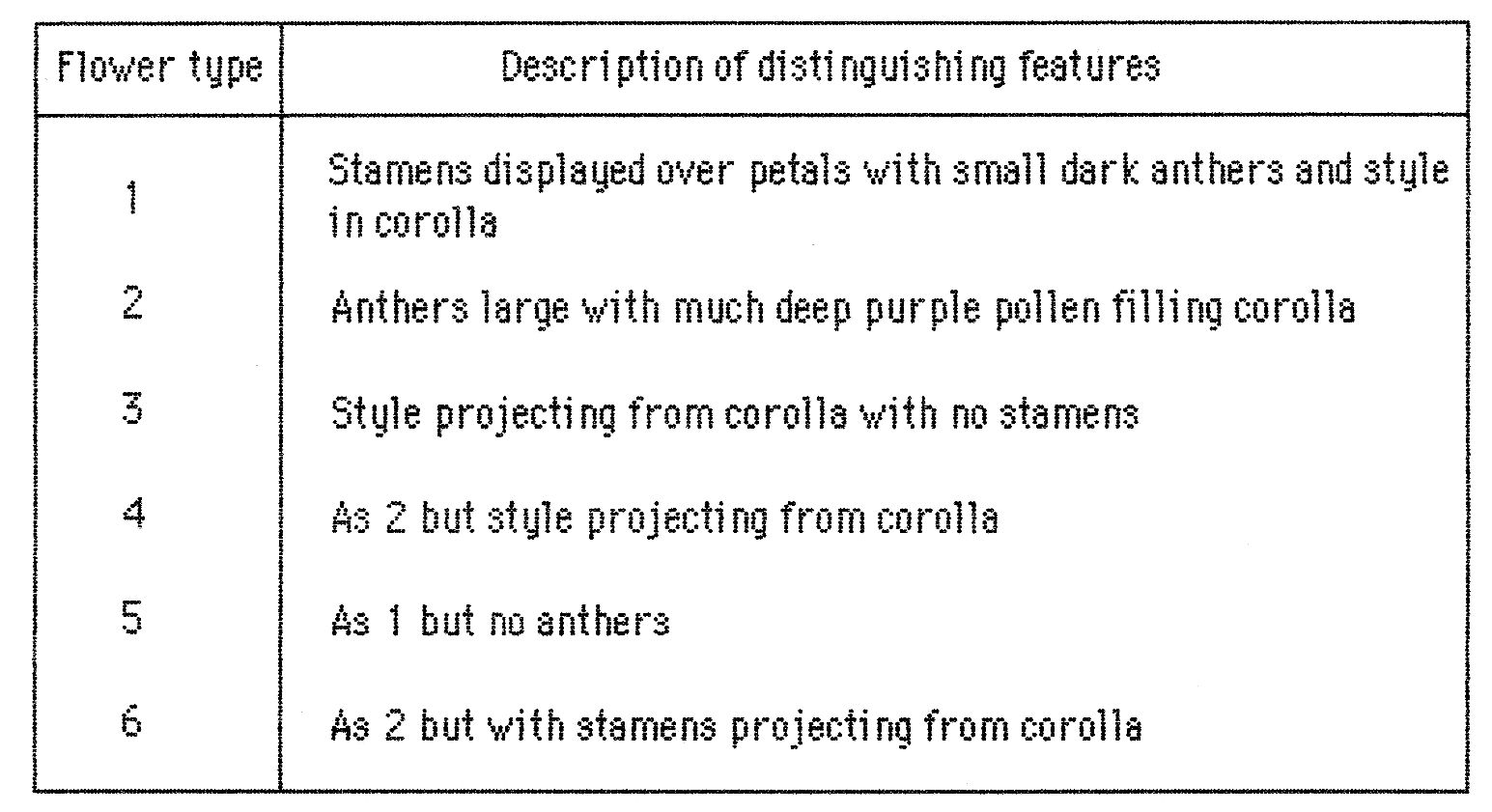
First report August 1987
Silene maritima is the only persistent perennial ground cover on the upper part of the coastal slope to the north of Skomer Head where it forms small low growing patches with a few isolated individual cushions about 0.5rn in diameter. These plants vary with regard to the size of the flowers, the coloration of the corolla, the size and position of the anthers, stamens and style, and the time of flowering. They also probably vary in their growth rates. The two extremes of corolla colour are cream pale green to purple veined. The purple variety is the commonest. Plants differ in the absolute size of the flowers and the relative proportions of their parts. Generally the latter variations are most obvious in the ratio of length to breadth in the corolla which is either narrow, or broad. The commonest form of sexual development of the flower is for the stamens to spread out from the corolla with small dark anthers displayed against the white petals, and the style out of sight in the corolla tube. There are two other less common forms, both associated with smaller flowers. One form has an exaggerated development of the anthers which become enlarged with purple pollen, and have shortened stamens so that the anthers block the upper end of the corolla to give the flower a purple centre. In this form the development of the style is retarded. In the other form, the style is enlarged to project from from the corolla and the stamens remain immature clustered around the bottom of the ovary. Often, one form or the other dominates any particular plant but occasional normal flowers also occur. There are other flower variants involving abnormal sexual development.
All forms listed in Table I also occurred in the large, vigorous community of Silene at the Wick during the 1980s (Table 2).
Table 2 Different types of flowers found at The Wick
A quantitative assessment of the relative numbers of flowers conforming to these 6 types was obtained by dropping a 0.5 m2 quadrat every five metres along a 100 metre transect from the edge of the riff path east across Wick Saddle towards the large but circle, were the Silene community terminated (Table 1). Each quadrat sampled one plant. The density of flowers varied from about 20 to 90,. Eight out of the twenty samples were of the normal type with no variations, four had a majority of flowers with abnormal sexual development, and the remaining eight samples had predominantly normal flowers. There was no obvious trend for the density of flowers or the flower variation to be related to distance along the transect from the cliff edge (Table 3).
Table 3 Numbers of different types of flowers in 0.5m2 quadrats ub a 100m transect east from the cliff footpath at the Wick
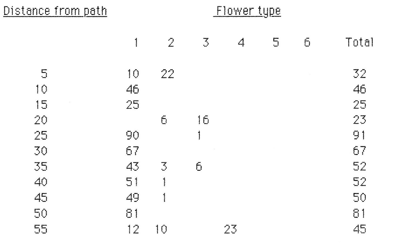
Table 2 Part 2

The largest variation in width of corolla (C.V.= 19), and the smallest variation in height (C.V.=10). The data for height were normally distributed the others were polymodal or skewed.
The variable width data were bimodally distributed with cohorts at 0.7 and 0.9 cm. The first cohort (the narrow corolla variant) contained predominantly plants No 4 and 1 (which made up about 60% of the samples in the cohort). Each of these two plants had 60% and 50% of their flowers in this category respectively. The remaining flowers in this category came mostly from plants No 6 and 2, which had respectively 30% and 20g of their flowers in this category.
The second cohort (the broad corolla variant) contained mostly flowers from plants No 3 and 5 which made up 60% of the cohort samples. The remaining flowers came mostly from plant No 2 and 7 with each plant having 30% of its flowers in this category.
Width of the corolla was not related to either corolla height or flower diameter in these two cohorts.
Overall however short corollas tended to be wide (p>0.057; R= 0.279) and large flowers tended to have narrow corollas (p>0.05; R= 0.332).
In terms representative plants with no overlap with each other the plant with the narrowest corolla was No 6 and the one with the broadest was No 7 (twice as wide as No 6) and the one with an intermediate width was Nol.
In terms of the ratios of height and diameter to width there were two cohorts. Most plants had mean ratios H:W of 1.8 and D:W of 2.0. Plants No 1 and 6 had ratios of about 2.3 and 2.6 respectively which accounted for about 70% of the samples in the high ratio cohorts.
Regression analysis produced significant correlations of p>0.001 between width and diameter and width and height. The highest regression coefficient was found between height and flower diameter.
Removing plants No 1 and 6 from the total data set had very little effect on the mean ratios with width and their coefficients of variability.
Conclusions
There is a strong selection for height of corolla, and a lower selection for width of corolla and flower size. There are two corolla morphs, which differ in width and which do not completely segregate with individual plants. The corresponding two flower types do not have any significant relationship between coroa hisht and flower diameter and the width of corolla. Plants having flowers in either of these categories appear to have a maximum of 50% of flowers showing the appropriate morph character and a minimum of about 30%.
Skomer: aerial surveys
Vegetation is more of a continuum than a set of distinct units. Holistic knowledge on vegetation heterogeneity, scenic patterns and species dynamics is therefore an indispensable prerequisite for identifying and understanding ecological processes and hence, providing subsequent insight for managing ecosystems . Geographic Information Systems (GIS) represent a considerable change in environmental data management, as they connect territorial information to different databases, allowing for the “integration” of the territory, adding and producing new information. The use of remote sensing tools, permits the gathering of many kinds of territorial information and the investigation of aspects that are difficult to monitor.
The ability to estimate plant distributions over large areas (i.e., several hectares) using traditional approaches (transect or quadrat methods) is generally limited because of the time and expense required. Intensive plant surveys may also result in unacceptable levels of disturbance to sensitive ecosystems due to soil compaction, disruption of soil organic layers, trampling, and vegetation damage. This is an important issue on Skomer where there is a high density of relatively shallow nesting burrows. Remote sensing via satellites provides information on landforms and the general distribution of vegetation types over large areas. However, it is unlikely to provide adequate spatial or temporal resolution for determining the distributions of individual species or fine-scale differentiation among surface landscape features and vegetation types. Moreover, available satellite images may not represent optimal phenological stages for the identification of different species and vegetation types. Manned aircraft and large drone surveys can have increased resolution, but are prohibitively expensive for most investigations. Generally, they do not provide a high enough resolution to assess the distributions and compositions of plant communities. On the other hand, utilization of micro–unmanned aerial vehicles (UAVs, unmanned aerial systems [UAS], small aerial drones) do provide adequate levels of image detail to estimate the distribution of individual plant species or vegetation types over several hectares at a relatively low cost. Therefore, in 2017, to get the holistic picture of Skomer’s vegetation, drone technology will be applied to make a digital surface model. The goal is to define the advantages and limitations of small aerial drone surveys covering the whole of the island for estimating the distributions of individual plant species and vegetation types making up the surface landscape at fine spatial scales. In particular, the aim is to plot the impact of rabbit behaviour. Hopefully this will be a fifty year old dream come true.